File:Historical expanse of Ainu.png
Nae heier resolution available.
Historical_expanse_of_Ainu.png (632 × 505 pixels, file size: 110 KB, MIME type: image/png)
Ootline
| Descreeption |
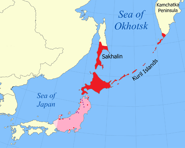
English: Historically attested range of Ainu (red) and suspected former range (pink) based on toponymic evidence (red dots), Matagi villages (purple), and Japanese isoglosses (western limit) with modern-day borders shown |
| Date | |
| Soorce |
Various, including Vovin, Alexander (2008) Man'yōshū to Fudoki ni Mirareru Fushigina Kotoba to Jōdai Nihon Retto ni Okeru Ainugo no Bunpu, Kokusai Nihon Bunka Kenkyū Sentā. Archived from the original on 11 Febuair 2014. Retrieved on 27 Mairch 2011. |
| Author | Kwamikagami |
| Other versions |
 |

Licensin
I, the copyright holder of this work, hereby publish it under the following licenses:
This file is licensed unner the Creative Commons Attribution-Share Alike 3.0 Unported license.
- Ye are free:
- tae share – tae copy, distribute an transmit the wirk
- tae remix – tae adapt the wirk
- Unner the follaein condeetions:
- attribution – Ye must attribute the wirk in the manner specified bi the author or licensor (but nae in ony way that suggests that thay endorse ye or yer uise o the wirk).
- share alik – If ye alter, transform, or big upon this wirk, ye mey distribute the resultin wirk anly unner the same or seemilar license tae this ane.

|
Permission is grantit tae copy, distribute an/or modify this document unner the terms o the GNU Free Documentation License, Version 1.2 or ony later version published bi the Free Software Foundation; wi no Invariant Sections, no Front-Cover Texts, an no Back-Cover Texts. A copy o the license is includit in the section enteetled GNU Free Documentation License. |
Ye mey select the license o yer choice.
File history
Clap oan ae date/time fer tae see the file aes it kithed at that time.
| Date/Time | Thummnail | Dimensions | Uiser | Comment | |
|---|---|---|---|---|---|
| current | 00:11, 29 Januar 2018 | | 632 × 505 (110 KB) | FogueraC | Reverted to version as of 00:34, 4 April 2013 (UTC) |
| 15:55, 18 Apryle 2017 |  | 632 × 505 (100 KB) | 일성강 | fixed | |
| 00:34, 4 Apryle 2013 |  | 632 × 505 (110 KB) | Kwamikagami | (didn't take) | |
| 00:29, 4 Apryle 2013 |  | 632 × 505 (110 KB) | Kwamikagami | nonparallel isoglosses | |
| 05:24, 18 December 2011 |  | 632 × 505 (110 KB) | Kwamikagami | per Japanese isoglosses | |
| 14:14, 7 Mey 2011 |  | 632 × 505 (110 KB) | Kwamikagami | add matagi villages | |
| 05:33, 8 Apryle 2011 |  | 632 × 505 (110 KB) | Kwamikagami | Shōnai | |
| 08:03, 22 Februar 2011 |  | 632 × 505 (110 KB) | Kwamikagami | oops--kamchatka historically attested | |
| 07:57, 22 Februar 2011 |  | 632 × 505 (110 KB) | Kwamikagami | reduced area in Kamchatka, per ''Atlas of languages of intercultural communication in the Pacific, Asia and the Americas'', Map 112 | |
| 02:26, 22 Februar 2011 |  | 632 × 505 (110 KB) | Kwamikagami | add river in Iwate |
Eimage airtins
The follaein pages airts tae this image:
Global file uisage
The follaein ither wikis uise this file:
- Uisage on af.wikipedia.org
- Uisage on als.wikipedia.org
- Uisage on bcl.wikipedia.org
- Uisage on be.wikipedia.org
- Uisage on bn.wikipedia.org
- Uisage on cs.wikipedia.org
- Uisage on da.wikipedia.org
- Uisage on de.wikipedia.org
- Uisage on en.wikipedia.org
- Uisage on en.wikiversity.org
- Uisage on es.wikipedia.org
- Uisage on et.wikipedia.org
- Uisage on fa.wikipedia.org
- Uisage on fi.wikipedia.org
- Uisage on fo.wikipedia.org
- Uisage on frr.wikipedia.org
- Uisage on fr.wikipedia.org
- Uisage on fy.wikipedia.org
- Uisage on gl.wikipedia.org
- Uisage on hsb.wikipedia.org
- Uisage on hu.wikipedia.org
- Uisage on hy.wikipedia.org
- Uisage on id.wikipedia.org
- Uisage on it.wikipedia.org
- Uisage on kk.wikipedia.org
View mair global usage o this file.