File:Gulf of Aden map.png
Size o this luikower: 719 × 600 pixels. Ither resolutions: 288 × 240 pixels | 575 × 480 pixels | 921 × 768 pixels | 1,227 × 1,024 pixels | 2,500 × 2,086 pixels.
Oreeginal file (2,500 × 2,086 pixels, file size: 765 KB, MIME type: image/png)
Ootline
| Descreeption |
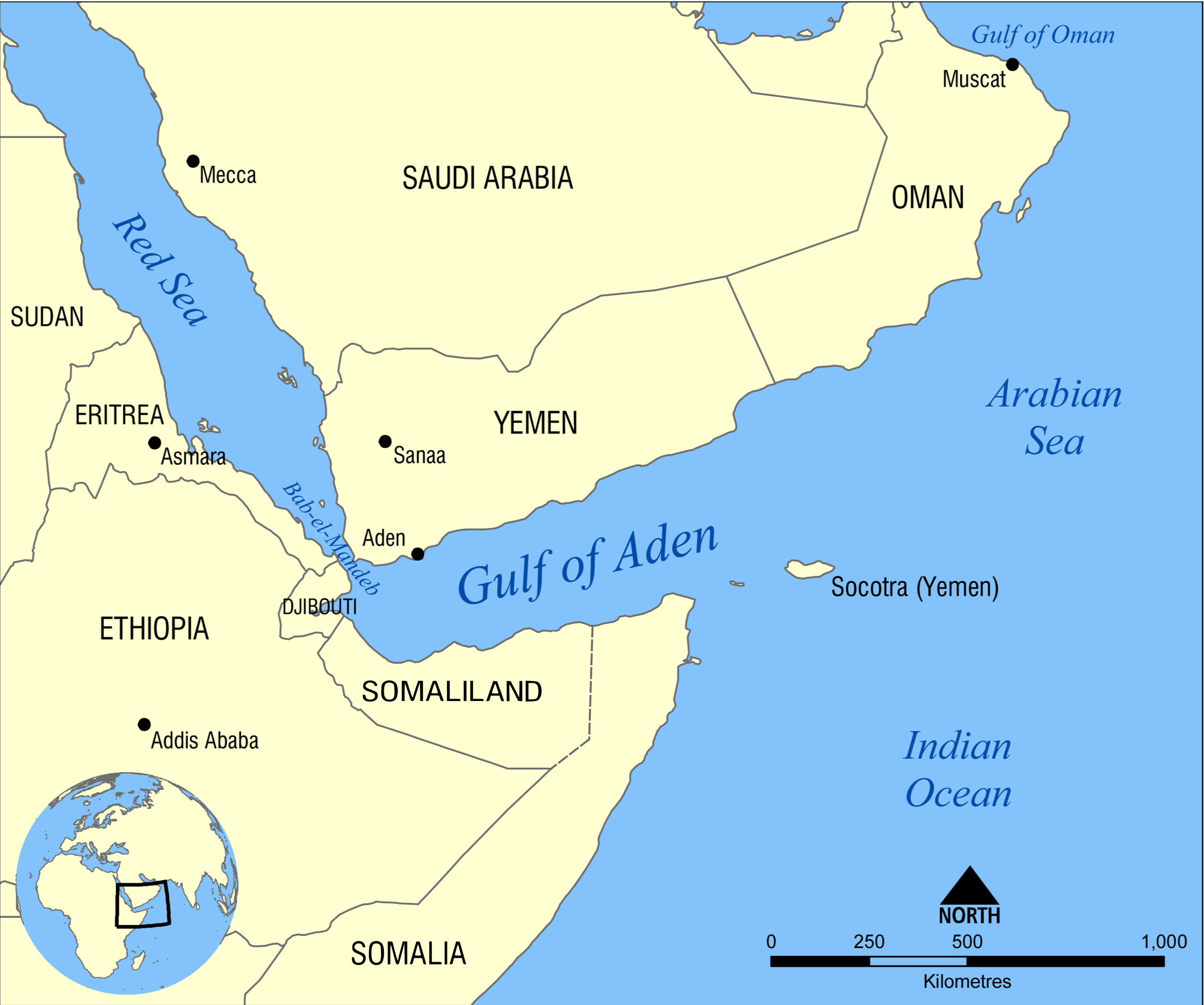
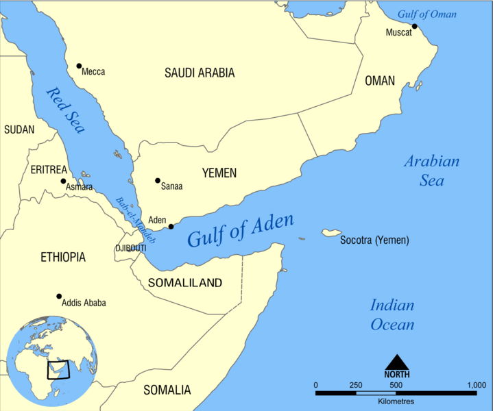
Eesti: Adeni lahe kaart English: Map showing the location of the Gulf of Aden, located between Yemen and Somalia. Nearby bodies of water include the Indian Ocean, Red Sea, Arabian Sea, and the Bab-el-Mandeb Strait. Español: Golfo de Adén, localizado en el Mar arábigo, entre Yemén y Somalia (o Somalilandia). Hrvatski: Adenski zaljev Қазақша: Аден шығанағының орналасуын көрсететін қазақтілді карта. Русский: Карта на казахском языке, показывающяя местоположение Аденского залива. العربية : خريطة تُبيِّن موقع خليج عدن بين اليمن والصومال. المُسطحات المائيَّة المُجاورة هي: المُحيط الهندي والبحر الأحمر وبحر العرب ومضيق باب المندب. |
||
| Date | |||
| Soorce | Ain wirk | ||
| Author | NormanEinstein | ||
| Other versions |
[]
|


Licensin
I, the copyright holder of this work, hereby publish it under the following licenses:
This file is licensed unner the Creative Commons Attribution-Share Alike 3.0 Unported license.
- Ye are free:
- tae share – tae copy, distribute an transmit the wirk
- tae remix – tae adapt the wirk
- Unner the follaein condeetions:
- attribution – Ye must attribute the wirk in the manner specified bi the author or licensor (but nae in ony way that suggests that thay endorse ye or yer uise o the wirk).
- share alik – If ye alter, transform, or big upon this wirk, ye mey distribute the resultin wirk anly unner the same or seemilar license tae this ane.

|
Permission is grantit tae copy, distribute an/or modify this document unner the terms o the GNU Free Documentation License, Version 1.2 or ony later version published bi the Free Software Foundation; wi no Invariant Sections, no Front-Cover Texts, an no Back-Cover Texts. A copy o the license is includit in the section enteetled GNU Free Documentation License. |
Ye mey select the license o yer choice.
File history
Clap oan ae date/time fer tae see the file aes it kithed at that time.
| Date/Time | Thummnail | Dimensions | Uiser | Comment | |
|---|---|---|---|---|---|
| current | 04:57, 28 December 2023 | | 2,500 × 2,086 (765 KB) | Subayerboombastic | Reverted to version as of 14:50, 25 December 2023 (UTC) |
| 21:36, 27 December 2023 |  | 841 × 703 (134 KB) | SawsanJojo | Reverted to version as of 07:20, 5 November 2023 (UTC) | |
| 14:50, 25 December 2023 |  | 2,500 × 2,086 (765 KB) | Jacob300 | Reverted to version as of 21:19, 2 November 2023 (UTC) | |
| 07:20, 5 November 2023 |  | 841 × 703 (134 KB) | Salma3232 | Reverted to version as of 17:50, 29 September 2023 (UTC) | |
| 21:19, 2 November 2023 |  | 2,500 × 2,086 (765 KB) | Jacob300 | Reverted to version as of 12:14, 22 October 2022 (UTC) | |
| 17:50, 29 September 2023 |  | 841 × 703 (134 KB) | Seemsrathytaway | update control https://www.blackagendareport.com/blue-flag-over-las-anod-victory-somali-nationalists | |
| 12:14, 22 October 2022 |  | 2,500 × 2,086 (765 KB) | Jacob300 | Reverted to version as of 15:14, 13 October 2021 (UTC) | |
| 17:44, 7 September 2022 |  | 2,500 × 2,086 (204 KB) | Anwar8989 | Reverted to version as of 18:22, 29 January 2009 (UTC) | |
| 15:14, 13 October 2021 |  | 2,500 × 2,086 (765 KB) | Gebagebo | fixed Somaliland's eastern border | |
| 17:35, 13 Mey 2021 |  | 2,500 × 2,086 (763 KB) | Jacob300 | Added Somaliland to map. |
Eimage airtins
The'r nae pages airts tae this eimage.
Global file uisage
The follaein ither wikis uise this file:
- Uisage on af.wikipedia.org
- Uisage on ar.wikipedia.org
- Uisage on ast.wikipedia.org
- Uisage on az.wikipedia.org
- Uisage on bn.wikipedia.org
- Uisage on bs.wikipedia.org
- Uisage on ca.wikipedia.org
- Uisage on ce.wikipedia.org
- Uisage on cs.wikipedia.org
- Uisage on el.wikipedia.org
- Uisage on en.wikipedia.org
- Uisage on en.wikinews.org
- Uisage on eo.wikipedia.org
- Uisage on es.wikipedia.org
- Uisage on eu.wikipedia.org
- Uisage on fa.wikipedia.org
- Uisage on fi.wikipedia.org
- Uisage on fr.wikipedia.org
- Uisage on gl.wikipedia.org
- Uisage on gu.wikipedia.org
- Uisage on he.wikipedia.org
- Uisage on hu.wikipedia.org
- Uisage on hy.wikipedia.org
- Uisage on id.wikipedia.org
- Uisage on ilo.wikipedia.org
- Uisage on it.wikipedia.org
- Uisage on ja.wikipedia.org
- Uisage on ka.wikipedia.org
- Uisage on kcg.wikipedia.org
View mair global usage o this file.