File:Grimsby Dock Tower.jpg
Oreeginal file (523 × 640 pixels, file size: 99 KB, MIME type: image/jpeg)
Ootline
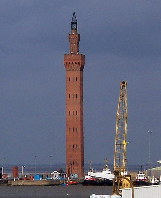
This is a photo of listed building number 1379870. |
| Camera location | | View this and other nearby images on: OpenStreetMap |
|---|
| Object location | | View this and other nearby images on: OpenStreetMap |
|---|
_region:GB-GBN_heading:22.00&language=sco)
| Descreeption |
Grimsby Dock Tower Note that the Grimsby tower isn't a hydraulic accumulator (it's in the category because it's an important part of their history). Towers such as Grimsby achieved high pressures simply by their height, expensive though these were to construct. It was soon realised that a pressurised cistern with a heavy iron or concrete weight on it gave the same results, at much less cost.
For more information on the tower see Link |
| Date | |
| Soorce | Geograph |
| Author | David Wright (Uploaded by User:PeterJewell) |
| Permission (Reuisin this file) |
Creative Commons: Attribution-ShareAlike 2.0 |
Licensin

|
This image was taken from the Geograph project collection. See this photograph's page on the Geograph website for the photographer's contact details. The copyright on this image is owned by David Wright and is licensed for reuse under the Creative Commons Attribution-ShareAlike 2.0 license.
|
- Ye are free:
- tae share – tae copy, distribute an transmit the wirk
- tae remix – tae adapt the wirk
- Unner the follaein condeetions:
- attribution – Ye must attribute the wirk in the manner specified bi the author or licensor (but nae in ony way that suggests that thay endorse ye or yer uise o the wirk).
- share alik – If ye alter, transform, or big upon this wirk, ye mey distribute the resultin wirk anly unner the same or seemilar license tae this ane.
File history
Clap oan ae date/time fer tae see the file aes it kithed at that time.
| Date/Time | Thummnail | Dimensions | Uiser | Comment | |
|---|---|---|---|---|---|
| current | 00:41, 17 Julie 2007 | | 523 × 640 (99 KB) | PeterJewell | {{Information |Description= |Source= |Date= |Author= |Permission= |other_versions= }} |
Eimage airtins
The'r nae pages airts tae this eimage.
Global file uisage
The follaein ither wikis uise this file:
- Uisage on ar.wikipedia.org
- Uisage on arz.wikipedia.org
- Uisage on azb.wikipedia.org
- Uisage on be.wikipedia.org
- Uisage on ceb.wikipedia.org
- Uisage on cy.wikipedia.org
- Uisage on da.wikipedia.org
- Uisage on de.wikipedia.org
- Uisage on de.wikivoyage.org
- Uisage on en.wikipedia.org
- Uisage on en.wikivoyage.org
- Uisage on eo.wikipedia.org
- Uisage on es.wikipedia.org
- Uisage on eu.wikipedia.org
- Uisage on fa.wikipedia.org
- Uisage on fi.wikipedia.org
- Uisage on frr.wikipedia.org
- Uisage on fr.wikipedia.org
- Uisage on ga.wikipedia.org
- Uisage on he.wikipedia.org
- Uisage on id.wikipedia.org
- Uisage on it.wikipedia.org
- Uisage on it.wikivoyage.org
- Uisage on ko.wikipedia.org
- Uisage on lld.wikipedia.org
- Uisage on lt.wikipedia.org
- Uisage on nl.wikipedia.org
- Uisage on nn.wikipedia.org
- Uisage on no.wikipedia.org
- Uisage on ro.wikipedia.org
- Uisage on ru.wikipedia.org
- Uisage on simple.wikipedia.org
- Uisage on sr.wikipedia.org
- Uisage on sv.wikipedia.org
- Uisage on tt.wikipedia.org
- Uisage on uk.wikipedia.org
- Uisage on ur.wikipedia.org
- Uisage on www.wikidata.org
- Uisage on zh.wikipedia.org