File:Ganges-Brahmaputra-Meghna basins.jpg
Size o this luikower: 800 × 443 pixels. Ither resolutions: 320 × 177 pixels | 640 × 354 pixels | 1,024 × 567 pixels | 1,403 × 777 pixels.
Oreeginal file (1,403 × 777 pixels, file size: 1.09 MB, MIME type: image/jpeg)
Ootline
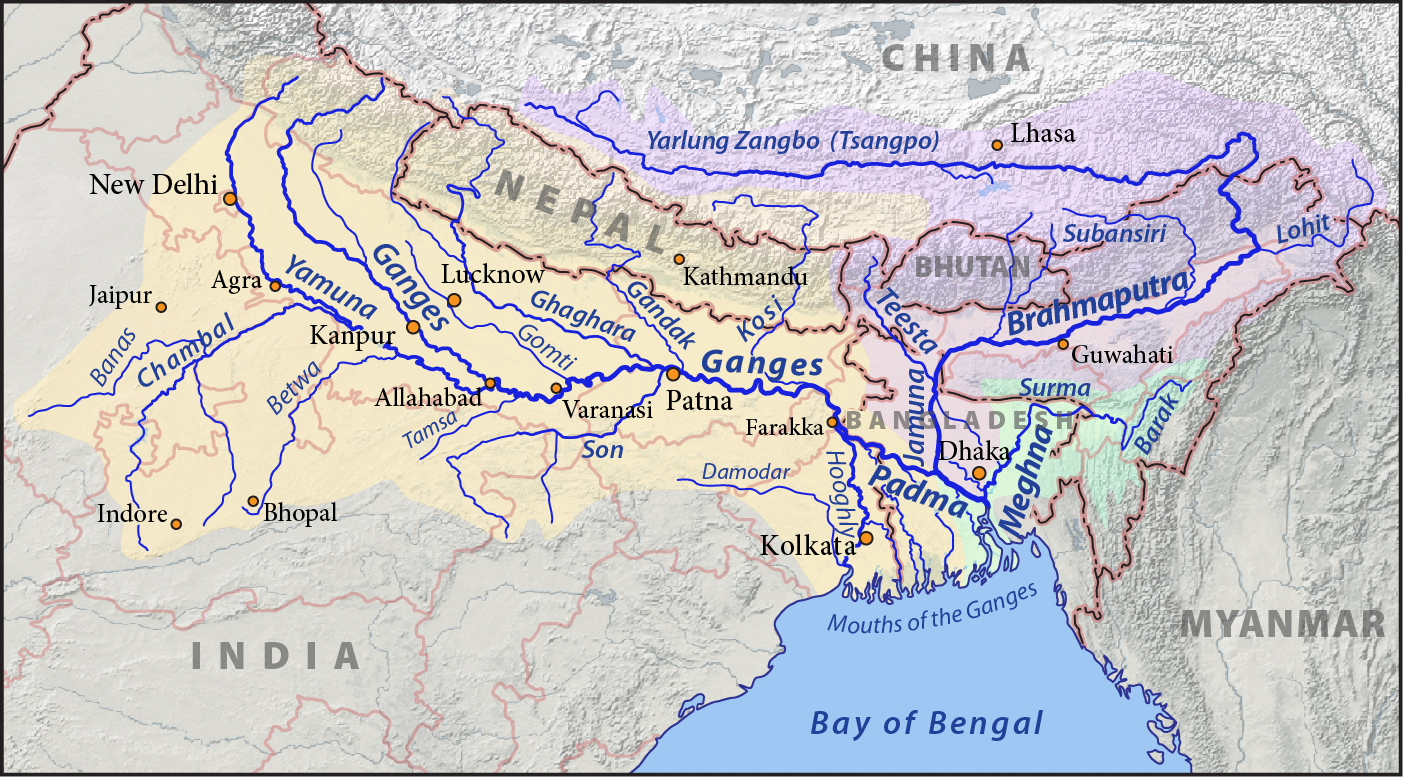
| Descreeption |
English: This is a map of the Ganges (yellow), Brahmaputra (violet), and Meghna (green) drainage basins. Created with ArcExplorer and Adobe Illustrator, based on Natural Earth data. |
| Date | |
| Soorce | Ain wirk |
| Author | Pfly |
Licensin
I, the copyright holder of this work, hereby publish it under the following licenses:
This file is licensed unner the Creative Commons Attribution-Share Alike 3.0 Unported license.
- Ye are free:
- tae share – tae copy, distribute an transmit the wirk
- tae remix – tae adapt the wirk
- Unner the follaein condeetions:
- attribution – Ye must attribute the wirk in the manner specified bi the author or licensor (but nae in ony way that suggests that thay endorse ye or yer uise o the wirk).
- share alik – If ye alter, transform, or big upon this wirk, ye mey distribute the resultin wirk anly unner the same or seemilar license tae this ane.

|
Permission is grantit tae copy, distribute an/or modify this document unner the terms o the GNU Free Documentation License, Version 1.2 or ony later version published bi the Free Software Foundation; wi no Invariant Sections, no Front-Cover Texts, an no Back-Cover Texts. A copy o the license is includit in the section enteetled GNU Free Documentation License. |
Ye mey select the license o yer choice.
File history
Clap oan ae date/time fer tae see the file aes it kithed at that time.
| Date/Time | Thummnail | Dimensions | Uiser | Comment | |
|---|---|---|---|---|---|
| current | 00:46, 1 Mey 2011 | | 1,403 × 777 (1.09 MB) | Pfly | A few minor tweaks to improve readability |
| 21:21, 30 Apryle 2011 |  | 1,404 × 778 (1.09 MB) | Pfly | Adjusted width of Yamuna River. | |
| 07:43, 30 Apryle 2011 |  | 1,405 × 778 (1.09 MB) | Pfly | {{Information |Description ={{en|1=This is a map of the Ganges (orange), Brahmaputra (violet), and Meghna (green) drainage basins. }} |Source ={{own}} |Author =[[User:Pfly|Pf |
Eimage airtins
The'r nae pages airts tae this eimage.
Global file uisage
The follaein ither wikis uise this file:
- Uisage on af.wikipedia.org
- Uisage on ar.wikipedia.org
- Uisage on ar.wikiversity.org
- Uisage on arz.wikipedia.org
- Uisage on ast.wikipedia.org
- Uisage on as.wikipedia.org
- Uisage on awa.wikipedia.org
- Uisage on azb.wikipedia.org
- Uisage on bg.wikipedia.org
- Uisage on bh.wikipedia.org
- Uisage on bn.wikipedia.org
- Uisage on bn.wikivoyage.org
- Uisage on bxr.wikipedia.org
- Uisage on ca.wikipedia.org
- Uisage on cs.wikipedia.org
- Uisage on de.wikipedia.org
- Uisage on dty.wikipedia.org
- Uisage on en.wikipedia.org
- Uisage on en.wikivoyage.org
- Uisage on eo.wikipedia.org
View mair global usage o this file.