File:Europe EU laea location map.svg

Size of this PNG preview of this SVG file: 701 × 599 pixels. Ither resolutions: 281 × 240 pixels | 561 × 480 pixels | 898 × 768 pixels | 1,198 × 1,024 pixels | 2,395 × 2,048 pixels | 1,401 × 1,198 pixels.
Oreeginal file (SVG file, nominallie 1,401 × 1,198 pixels, file size: 1.43 MB)
Ootline
| Descreeption |
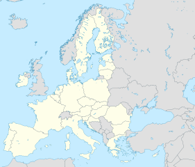
Deutsch: Positionskarte Europa, Europäische Union; Politisch mit Staatsgrenzen; Flächentreue Azimutalprojektion
English: Location map Europe, European Union; Political with state boundaries; Lambert azimuthal equal-area projection
Français : Carte de localisationEurope, Union européenne; Politique avec frontières d'Etats; Projection azimuthale de Lambert
|
| Date | |
| Soorce |
Ain wirk
|
| Author | Alexrk2 |
| Other versions |
[]
|


.svg)


|
This map has been made or improved in the German Kartenwerkstatt (Map Lab). You can propose maps to improve as well.
|
Licensin
I, the copyright holder of this work, hereby publish it under the following license:
This file is licensed unner the Creative Commons Attribution-Share Alike 3.0 Unported license.
- Ye are free:
- tae share – tae copy, distribute an transmit the wirk
- tae remix – tae adapt the wirk
- Unner the follaein condeetions:
- attribution – Ye must attribute the wirk in the manner specified bi the author or licensor (but nae in ony way that suggests that thay endorse ye or yer uise o the wirk).
- share alik – If ye alter, transform, or big upon this wirk, ye mey distribute the resultin wirk anly unner the same or seemilar license tae this ane.
File history
Clap oan ae date/time fer tae see the file aes it kithed at that time.
| Date/Time | Thummnail | Dimensions | Uiser | Comment | |
|---|---|---|---|---|---|
| current | 05:01, 11 Mairch 2020 | | 1,401 × 1,198 (1.43 MB) | Ratherous | Fix inland water |
| 10:21, 1 Februar 2020 |  | 1,401 × 1,198 (1.84 MB) | Thayts | fixing inland water | |
| 10:06, 1 Februar 2020 |  | 1,401 × 1,198 (1.48 MB) | Mibblepedia | Reverted to version as of 09:30, 1 February 2020 (UTC) - Browser refresh issue, sorry for the spam | |
| 09:53, 1 Februar 2020 |  | 1,401 × 1,198 (1.48 MB) | Mibblepedia | Meaningful change to try to fix upload | |
| 09:48, 1 Februar 2020 |  | 1,401 × 1,198 (1.48 MB) | Mibblepedia | Meaningless file change to try to fix upload | |
| 09:41, 1 Februar 2020 |  | 1,401 × 1,198 (1.48 MB) | Mibblepedia | Removed United Kingdom (again) | |
| 09:40, 1 Februar 2020 |  | 1,401 × 1,198 (1.48 MB) | Mibblepedia | Reverted to version as of 17:57, 8 September 2014 (UTC) - Reverting to older version to try to fix weirdness | |
| 09:32, 1 Februar 2020 |  | 1,401 × 1,198 (1.48 MB) | Mibblepedia | Reverted to version as of 09:30, 1 February 2020 (UTC) - Something weird happened | |
| 09:30, 1 Februar 2020 |  | 1,401 × 1,198 (1.48 MB) | Mibblepedia | Removed United Kingdom | |
| 09:30, 1 Februar 2020 |  | 1,401 × 1,198 (1.48 MB) | Thayts | UK is out |
Eimage airtins
The follaein pages airts tae this image:
Global file uisage
The follaein ither wikis uise this file:
- Uisage on als.wikipedia.org
- Uisage on ar.wikipedia.org
- Uisage on azb.wikipedia.org
- Uisage on az.wikipedia.org
- Uisage on ba.wikipedia.org
- Uisage on bn.wikipedia.org
- Uisage on ceb.wikipedia.org
- Uisage on da.wikipedia.org
- Uisage on de.wikipedia.org
- Uisage on en.wikipedia.org
- European Environment Agency
- Stockholm
- Nicosia
- Valletta
- Drottningholm
- Kiruna
- Nykøbing Falster
- European Capital of Culture
- Europol
- European Agency for Safety and Health at Work
- European Union Aviation Safety Agency
- List of urban areas in the European Union
- Broby, Sweden
- Tumba, Sweden
- Märsta
- Kungsängen
- Gustavsberg, Värmdö Municipality
- Åkersberga
- Örbyhus
- Torsås
- Kristianstad
- Osby
- Åstorp
- Ystad
- Lund
View mair global usage o this file.