File:Elam Map.jpg
Nae heier resolution available.
Elam_Map.jpg (300 × 250 pixels, file size: 28 KB, MIME type: image/jpeg)
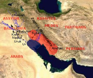
Map of Elam (approximate extension of the Elamite Empire is shown in red, the size of the Persian Gulf in the Bronze Age is indicated in blue (violet?))

|
Permission is grantit tae copy, distribute an/or modify this document unner the terms o the GNU Free Documentation License, Version 1.2 or ony later version published bi the Free Software Foundation; wi no Invariant Sections, no Front-Cover Texts, an no Back-Cover Texts. A copy o the license is includit in the section enteetled GNU Free Documentation License. |
| This file is licensed unner the Creative Commons Attribution-Share Alike 3.0 Unported license. | ||
| ||
| This licensing tag was added to this file as part of the GFDL licensing update. |
by en:User:Dbachmann, based on [1] archive copy at the Wayback Machine, [2] archive copy at the Wayback Machine.


![[1]](http://www.zoroastriankids.com/map_elam.gif)
![[2]](http://home.columbus.rr.com/malyan/Resources/mesoiranmap.gif)
File history
Clap oan ae date/time fer tae see the file aes it kithed at that time.
| Date/Time | Thummnail | Dimensions | Uiser | Comment | |
|---|---|---|---|---|---|
| current | 09:01, 28 Julie 2005 | | 300 × 250 (28 KB) | Dbachmann | update |
| 08:18, 26 Julie 2005 |  | 300 × 250 (23 KB) | Dbachmann | Map of Elam {{GFDL}} by en:User:Dbachmann, based on [http://www.zoroastriankids.com/map_elam.gif], [http://home.columbus.rr.com/malyan/Resources/mesoiranmap.gif]. |
Eimage airtins
The'r nae pages airts tae this eimage.
Global file uisage
The follaein ither wikis uise this file:
- Uisage on af.wikipedia.org
- Uisage on am.wikipedia.org
- Uisage on ar.wikipedia.org
- Uisage on av.wikipedia.org
- Uisage on azb.wikipedia.org
- Uisage on ba.wikipedia.org
- Uisage on bg.wikipedia.org
- Uisage on bn.wikipedia.org
- Uisage on ca.wikipedia.org
- Uisage on ckb.wikipedia.org
- Uisage on cv.wikipedia.org
- Uisage on da.wikipedia.org
- Uisage on de.wikipedia.org
- Uisage on diq.wikipedia.org
- Uisage on el.wikipedia.org
- Uisage on en.wikipedia.org
- Uisage on es.wikipedia.org
- Uisage on et.wikipedia.org
- Uisage on eu.wikipedia.org
- Uisage on fa.wikipedia.org
- Uisage on fi.wikibooks.org
- Uisage on fr.wikipedia.org
- Uisage on gl.wikipedia.org
- Uisage on he.wikipedia.org
- Uisage on hi.wikipedia.org
- Uisage on hr.wikipedia.org
- Uisage on hu.wikipedia.org
View mair global usage o this file.