File:EU OCT and OMR map en.png
Size o this luikower: 800 × 492 pixels. Ither resolutions: 320 × 197 pixels | 640 × 394 pixels | 1,024 × 630 pixels | 1,280 × 788 pixels | 2,206 × 1,358 pixels.
Oreeginal file (2,206 × 1,358 pixels, file size: 1,003 KB, MIME type: image/png)

|
File:Special member state territories and the European Union.svg is a vector version o this file. It should be uised in place o this raster image when nae inferior.
File:EU OCT and OMR map en.png → File:Special member state territories and the European Union.svg
For mair information, see Help:SVG. |
 |
Ootline
| Descreeption |
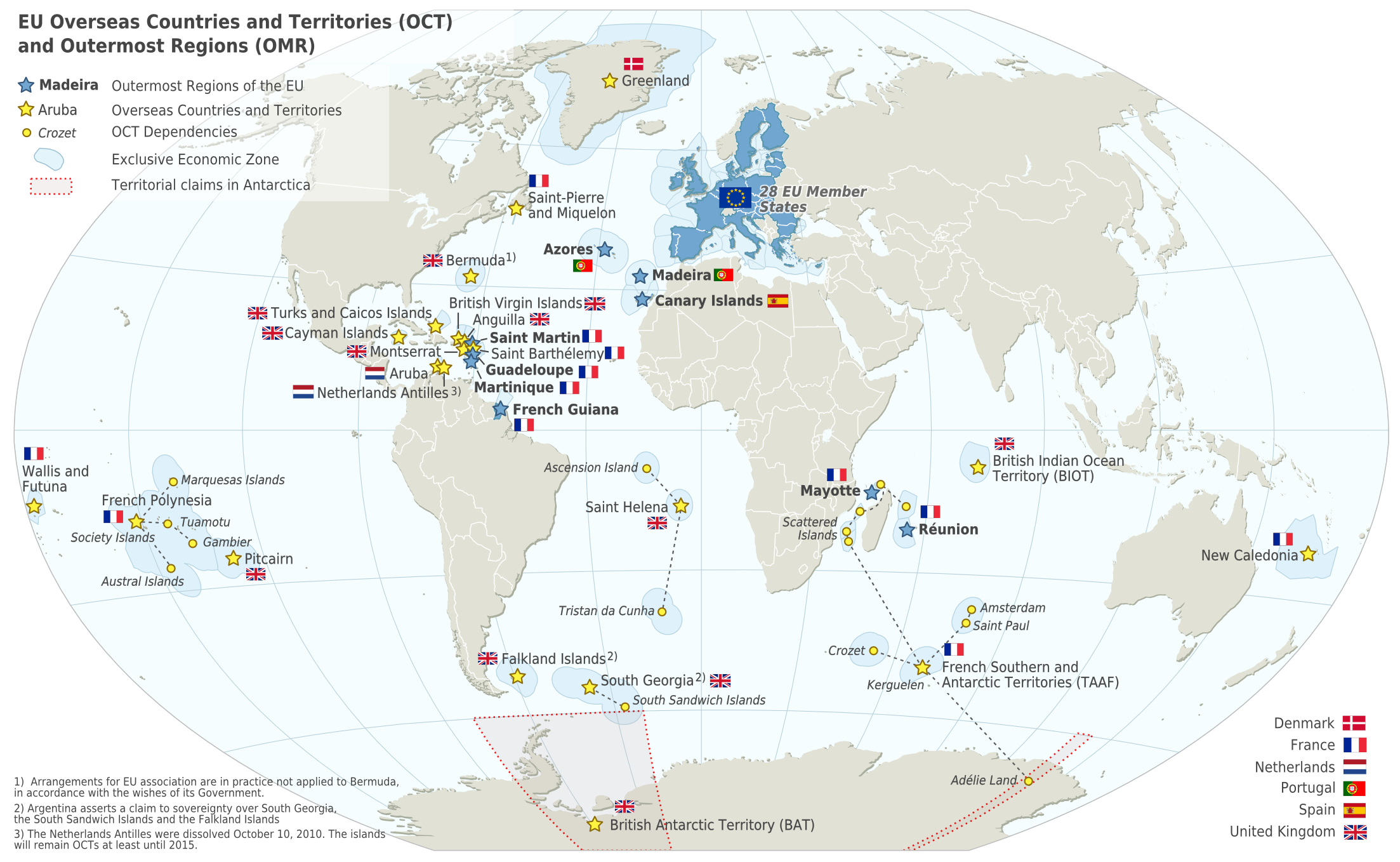
Deutsch: Karte der EU – Überseeische Länder und Hoheitsgebiete (OCT) und die Gebiete in äußerster Randlage (OMR). Diese Karte zeigt den räumlichen Geltungsbereich der Verträge der EU gemäß Artikel 52 des Vertrags über die Europäische Union und Artikel 355 des Vertrags über die Arbeitsweise der Europäischen Union.
Français : Carte de l’Union Européenne, en particulier les Pays et territoires d’outre-mer et les Régions ultrapériphériques. Cette carte montre la portée d’action territoriale des Traités de l’UE comme spécifié par l’Article 52 du Traité sur l’Union Européenne et l’Article 355 du Traité sur le Fonctionnement de l’Union Européenne.
English: Map of the EU – Overseas Countries and Territories (OCT) and Outermost Regions (OMR). This map shows the territorial scope of the Treaties of the EU as specified by Article 52 of the Treaty on European Union and Article 355 of the Treaty on the Functioning of the European Union. |
| Date | |
| Soorce | Natural Earth 1:50m (http://www.naturalearthdata.com) |
| Author | Alexrk2 |
| Other versions |
|
![[ar] Arabic version \ النسخة العربية](http://commons.wikimedia.org/wiki/File:Map-Europe-Outermost-regions-ar.PNG)
![[de] German version / deutsche Version](http://commons.wikimedia.org/wiki/File:Map-Europe-Outermost-regions-de.png)
![[fr] French version / version français](http://commons.wikimedia.org/wiki/File:Map-Europe-Outermost-regions-fr.png)


|
This map has been made or improved in the German Kartenwerkstatt (Map Lab). You can propose maps to improve as well.
|
Licensin
I, the copyright holder of this work, hereby publish it under the following license:
This file is licensed unner the Creative Commons Attribution-Share Alike 3.0 Unported license.
- Ye are free:
- tae share – tae copy, distribute an transmit the wirk
- tae remix – tae adapt the wirk
- Unner the follaein condeetions:
- attribution – Ye must attribute the wirk in the manner specified bi the author or licensor (but nae in ony way that suggests that thay endorse ye or yer uise o the wirk).
- share alik – If ye alter, transform, or big upon this wirk, ye mey distribute the resultin wirk anly unner the same or seemilar license tae this ane.
File history
Clap oan ae date/time fer tae see the file aes it kithed at that time.
| Date/Time | Thummnail | Dimensions | Uiser | Comment | |
|---|---|---|---|---|---|
| current | 06:14, 18 Februar 2024 | | 2,206 × 1,358 (1,003 KB) | Sqrt of 2 | Reverted to version as of 18:05, 12 June 2023 (UTC) |
| 16:08, 15 Januar 2024 |  | 2,206 × 1,358 (954 KB) | Multituberculata | Reverted to version as of 08:53, 31 May 2023 (UTC) | |
| 18:05, 12 Juin 2023 |  | 2,206 × 1,358 (1,003 KB) | DecafPotato | Reverted to version as of 14:48, 27 February 2019 (UTC) – The image includes UK territories, and was made prior to Brexit; please keep the UK in the map as part of the European Union for this reason | |
| 08:53, 31 Mey 2023 |  | 2,206 × 1,358 (954 KB) | Iktsokh | Note | |
| 20:01, 21 Mey 2023 |  | 2,206 × 1,358 (951 KB) | Iktsokh | Correction | |
| 09:56, 18 Mey 2023 |  | 2,206 × 1,358 (950 KB) | Iktsokh | Updated | |
| 14:48, 27 Februar 2019 |  | 2,206 × 1,358 (1,003 KB) | Radom1967 | Reverted to version as of 17:02, 22 March 2018 (UTC). No need | |
| 12:13, 25 Februar 2019 |  | 2,206 × 1,358 (999 KB) | Odemirense | Countries with overseas regions in dark blue | |
| 17:02, 22 Mairch 2018 |  | 2,206 × 1,358 (1,003 KB) | Maphobbyist | South Sudan border | |
| 18:24, 1 Januar 2014 |  | 2,206 × 1,358 (1 MB) | Alexrk2 | From 1 January 2014, the status of Mayotte will be that of an outermost region (COUNCIL DIRECTIVE 2013/61/EU of 17 December 2013) |
Eimage airtins
The follaein pages airts tae this image:
Global file uisage
The follaein ither wikis uise this file:
- Uisage on an.wikipedia.org
- Uisage on ar.wikipedia.org
- Uisage on ast.wikipedia.org
- Uisage on azb.wikipedia.org
- Uisage on bn.wikipedia.org
- Uisage on ca.wikipedia.org
- Uisage on cs.wikipedia.org
- Uisage on en.wikipedia.org
- Aruba
- Canary Islands
- Greenland
- Guadeloupe
- Martinique
- Mayotte
- Madeira
- Netherlands Antilles
- Réunion
- Overseas departments and regions of France
- Decolonisation of Africa
- History of colonialism
- Sint Maarten
- French Guiana
- User:Kazkaskazkasako/Books/All
- Caribbean Netherlands
- User:Tom29739/The EU
- User:Abyssal/bla
- User:Falcaorib
- List of colonies
- Uisage on en.wikiquote.org
- Uisage on en.wikivoyage.org
- Uisage on es.wikipedia.org
- Uisage on fa.wikipedia.org
- Uisage on fi.wikipedia.org
- Uisage on gl.wikipedia.org
- Uisage on id.wikipedia.org
- Uisage on ilo.wikipedia.org
- Uisage on it.wikipedia.org
- Uisage on ka.wikipedia.org
- Uisage on mk.wikipedia.org
- Uisage on nds-nl.wikipedia.org
View mair global usage o this file.