File:Charirivermap.png

Size o this luikower: 600 × 599 pixels. Ither resolutions: 240 × 240 pixels | 480 × 480 pixels | 1,001 × 1,000 pixels.
Oreeginal file (1,001 × 1,000 pixels, file size: 1.46 MB, MIME type: image/png)
Ootline
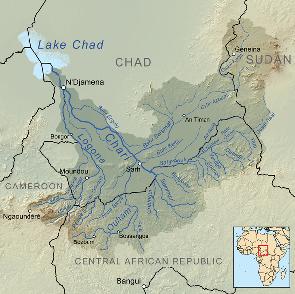
| Descreeption | Map showing the Chari River drainage basin. |
| Date | |
| Soorce | Ain wirk, Elevation data from SRTM, drainage basin from GTOPO [1], all other features from Vector Map. |
| Author | Kmusser |
Licensin
I, the copyright holder of this work, hereby publish it under the following license:
This file is licensed unner the Creative Commons Attribution-Share Alike 3.0 Unported license.
- Ye are free:
- tae share – tae copy, distribute an transmit the wirk
- tae remix – tae adapt the wirk
- Unner the follaein condeetions:
- attribution – Ye must attribute the wirk in the manner specified bi the author or licensor (but nae in ony way that suggests that thay endorse ye or yer uise o the wirk).
- share alik – If ye alter, transform, or big upon this wirk, ye mey distribute the resultin wirk anly unner the same or seemilar license tae this ane.
File history
Clap oan ae date/time fer tae see the file aes it kithed at that time.
| Date/Time | Thummnail | Dimensions | Uiser | Comment | |
|---|---|---|---|---|---|
| current | 16:26, 28 September 2010 | | 1,001 × 1,000 (1.46 MB) | Kmusser | connect Azoum and Salamat |
| 18:36, 8 Apryle 2010 |  | 1,000 × 1,000 (1.57 MB) | Kmusser | == Summary == {{Information |Description=Map showing the Chari River drainage basin. |Source={{own}}, Elevation data from SRTM, drainage basin from GTOPO [http://eros.usgs.gov/#/Find_Data/Products |
Eimage airtins
The'r nae pages airts tae this eimage.
Global file uisage
The follaein ither wikis uise this file:
- Uisage on af.wikipedia.org
- Uisage on ar.wikipedia.org
- Uisage on arz.wikipedia.org
- Uisage on be.wikipedia.org
- Uisage on bg.wikipedia.org
- Uisage on ca.wikipedia.org
- Uisage on ceb.wikipedia.org
- Uisage on cs.wikipedia.org
- Uisage on de.wikipedia.org
- Schari
- Logone
- Ouham
- Tschadbecken
- Salamat (Fluss)
- Bahr Aouk
- Nana Barya
- Pendé (Fluss)
- Fafa (Ouham)
- Mbéré (Fluss)
- Wikipedia:Löschkandidaten/5. Februar 2018
- Liste der Flüsse in der Zentralafrikanischen Republik
- Liste der Flüsse in Kamerun
- Vina (Mbéré)
- Liste der Flüsse im Tschad
- Logone Occidental (Fluss)
- Liste der Flüsse im Sudan
- Uisage on el.wikipedia.org
- Uisage on en.wikipedia.org
- Uisage on eo.wikipedia.org
- Uisage on es.wikipedia.org
View mair global usage o this file.