File:Borneo Locator Topography.png

Size o this luikower: 553 × 599 pixels. Ither resolutions: 221 × 240 pixels | 443 × 480 pixels | 709 × 768 pixels | 945 × 1,024 pixels | 1,605 × 1,739 pixels.
Oreeginal file (1,605 × 1,739 pixels, file size: 2.61 MB, MIME type: image/png)
Ootline
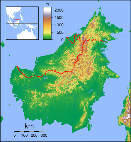
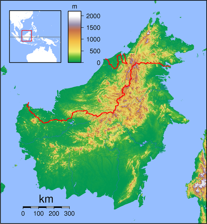
| Descreeption | Topographic locator map of Borneo. Created with GMT from public domain SRTM data. For non-locator version, see Image:Borneo Topography.png. Left:108 Bottom:-5 Right:120 Top:8 |
| Date | |
| Soorce | Ain wirk |
| Author | Sadalmelik |
Licensin
I, the copyright holder of this work, hereby publish it under the following licenses:

|
Permission is grantit tae copy, distribute an/or modify this document unner the terms o the GNU Free Documentation License, Version 1.2 or ony later version published bi the Free Software Foundation; wi no Invariant Sections, no Front-Cover Texts, an no Back-Cover Texts. A copy o the license is includit in the section enteetled GNU Free Documentation License. |
This file is licensed under the Creative Commons Attribution-Share Alike 3.0 Unported, 2.5 Generic, 2.0 Generic and 1.0 Generic license.
- Ye are free:
- tae share – tae copy, distribute an transmit the wirk
- tae remix – tae adapt the wirk
- Unner the follaein condeetions:
- attribution – Ye must attribute the wirk in the manner specified bi the author or licensor (but nae in ony way that suggests that thay endorse ye or yer uise o the wirk).
- share alik – If ye alter, transform, or big upon this wirk, ye mey distribute the resultin wirk anly unner the same or seemilar license tae this ane.
Ye mey select the license o yer choice.
File history
Clap oan ae date/time fer tae see the file aes it kithed at that time.
| Date/Time | Thummnail | Dimensions | Uiser | Comment | |
|---|---|---|---|---|---|
| current | 19:24, 1 September 2007 | | 1,605 × 1,739 (2.61 MB) | Sadalmelik | {{Information |Description=Topographic locator map of Borneo. Created wth GMT from public domain SRTM data. For non-locator version, see Image:Borneo Topography.png. Left:108 Bottom:-5 Right:120 Top:8 |Source=self-made |Date=Sep 1, 2007 |Author= [[Us |
Eimage airtins
The follaein pages airts tae this image:
Global file uisage
The follaein ither wikis uise this file:
- Uisage on ar.wikipedia.org
- Uisage on ban.wikipedia.org
- Taman Nasional Gunung Palung
- Taman Nasional Tanjung Puting
- Celuk Balikpapan
- Lis taman nasional ring Indonésia
- Taman Nasional Bukit Baka Bukit Raya
- Taman Nasional Betung Kerihun
- Taman Nasional Danu Sentarum
- Taman Nasional Kutai
- Taman Nasional Kayan Mentarang
- Taman Nasional Gunung Mulu
- Song Jeriji Saléh
- Taman Nasional Pagunungan Crocker
- Taman Nasional Pabukitan Tawau
- Taman Nasional Nusa Tiga
- Uisage on ba.wikipedia.org
- Uisage on bn.wikipedia.org
- Uisage on ceb.wikipedia.org
- Uisage on cs.wikipedia.org
- Uisage on da.wikipedia.org
- Uisage on de.wikipedia.org
- Uisage on en.wikipedia.org
- Tiga Island, Malaysia
- List of national parks in Malaysia
- Limbang
- Brunei International Airport
- Sipadan
- Ligitan
- Gunung Mulu National Park
- Samarinda
- Lawas
- Tabin Wildlife Reserve
- Tawau Hills National Park
- Tiga Island National Park
- Crocker Range National Park
- Tunku Abdul Rahman National Park
- Turtle Islands National Park (Malaysia)
- Tatau
- Kanowit
- Betong, Sarawak
- Batang Ai National Park
- Bako National Park
View mair global usage o this file.