File:Biafra independent state map-en.svg

Size of this PNG preview of this SVG file: 776 × 600 pixels. Ither resolutions: 311 × 240 pixels | 621 × 480 pixels | 994 × 768 pixels | 1,280 × 989 pixels | 2,560 × 1,978 pixels | 1,100 × 850 pixels.
Oreeginal file (SVG file, nominallie 1,100 × 850 pixels, file size: 472 KB)

|
This SVG file contains embedded text that can be translated into your language, using any capable SVG editor, text editor or the SVG Translate tool. For more information see: About translating SVG files. |
Ootline
| Descreeption |
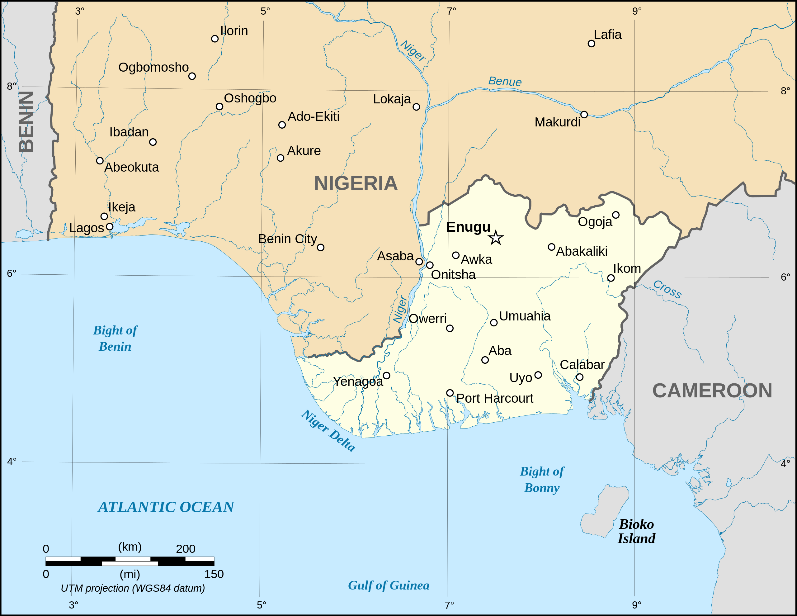
Català: Mapa de la república de Biafra en el maig 1967. English: Map of the secessionist state of the Republic of Biafra (1967 – 1970) as in May 1967. Note: The western boundary may not be accurate due to the low precision of the reference maps used which are also contradictory. Français : Carte en anglais de l'État sécessionniste de la République du Biafra (1967 – 1970) telle qu'en mai 1967. Note : La frontière Ouest peut ne pas être précise en raison de l'imprécision des cartes de référence qui sont aussi contradictoires. UTM projection ; WGS 84 datum |
||
| Date | September 2008 (new version) | ||
| Soorce |
Own work
|
||
| Author | Eric Gaba (Sting - fr:Sting) | ||
| Permission (Reuisin this file) |
|
||
| Other versions |
[]
|


|
|
This SVG file contains embedded text that can be translated into your language, using any capable SVG editor, text editor or the SVG Translate tool. For more information see: About translating SVG files. |
Licensin
I, the copyright holder of this work, hereby publish it under the following licenses:

|
Permission is grantit tae copy, distribute an/or modify this document unner the terms o the GNU Free Documentation License, Version 1.2 or ony later version published bi the Free Software Foundation; wi no Invariant Sections, no Front-Cover Texts, an no Back-Cover Texts. A copy o the license is includit in the section enteetled GNU Free Documentation License. |
| This file is licensed unner the Creative Commons Attribution-Share Alike 3.0 Unported license. | ||
| ||
| This licensing tag was added to this file as part of the GFDL licensing update. |
This file is licensed under the Creative Commons Attribution-Share Alike 2.5 Generic, 2.0 Generic and 1.0 Generic license.
- Ye are free:
- tae share – tae copy, distribute an transmit the wirk
- tae remix – tae adapt the wirk
- Unner the follaein condeetions:
- attribution – Ye must attribute the wirk in the manner specified bi the author or licensor (but nae in ony way that suggests that thay endorse ye or yer uise o the wirk).
- share alik – If ye alter, transform, or big upon this wirk, ye mey distribute the resultin wirk anly unner the same or seemilar license tae this ane.
Ye mey select the license o yer choice.
File history
Clap oan ae date/time fer tae see the file aes it kithed at that time.
| Date/Time | Thummnail | Dimensions | Uiser | Comment | |
|---|---|---|---|---|---|
| current | 19:21, 15 September 2023 | | 1,100 × 850 (472 KB) | Glrx | 256 kB workaround // Editing SVG source code using c:User:Rillke/SVGedit.js |
| 10:59, 15 September 2023 |  | 1,100 × 850 (472 KB) | KajenCAT | File uploaded using svgtranslate tool (https://svgtranslate.toolforge.org/). Added translation for ca. | |
| 04:51, 3 September 2008 |  | 1,100 × 850 (455 KB) | Sting | New version using the NGDC GSHHS and WDBII data ; new standard colors | |
| 17:54, 12 December 2006 |  | 1,100 × 850 (163 KB) | Sting | {{Information| |Description=Map of the secessionist state of the Republic of Biafra (1967 – 1970) |Source=Own work<br/>Background reference map : Microsoft Encarta atlas (1999 edition)<br/>Biafra independent state borders reference maps : [http://www.bi |
Eimage airtins
The follaein pages airts tae this image:
Global file uisage
The follaein ither wikis uise this file:
- Uisage on af.wikipedia.org
- Uisage on ar.wikipedia.org
- Uisage on ast.wikipedia.org
- Uisage on azb.wikipedia.org
- Uisage on be.wikipedia.org
- Uisage on bn.wikipedia.org
- Uisage on br.wikipedia.org
- Uisage on ca.wikipedia.org
- Uisage on cs.wikipedia.org
- Uisage on da.wikipedia.org
- Uisage on el.wikipedia.org
- Uisage on en.wikipedia.org
- Uisage on eo.wikipedia.org
- Uisage on es.wikipedia.org
- Uisage on et.wikipedia.org
- Uisage on eu.wikipedia.org
- Uisage on fa.wikipedia.org
- Uisage on gl.wikipedia.org
- Uisage on ha.wikipedia.org
- Uisage on he.wikipedia.org
- Uisage on hu.wikipedia.org
- Uisage on hy.wikipedia.org
- Uisage on id.wikipedia.org
- Uisage on ig.wikipedia.org
- Uisage on io.wikipedia.org
- Uisage on is.wikipedia.org
- Uisage on ja.wikipedia.org
View mair global usage o this file.