File:Bevölkerungsprognosen Cottbus.pdf

Size of this JPG preview of this PDF file: 800 × 566 pixels. Ither resolutions: 320 × 226 pixels | 640 × 453 pixels | 1,024 × 724 pixels | 1,280 × 905 pixels | 1,752 × 1,239 pixels.
Oreeginal file (1,752 × 1,239 pixels, file size: 68 KB, MIME type: application/pdf)

|
This graph image could be re-created using vector graphics as an SVG file. This has several advantages; see Commons:Media for cleanup for more information. If an SVG form of this image is available, please upload it and afterwards replace this template with
{{vector version available|new image name}}.
It is recommended to name the SVG file “Bevölkerungsprognosen Cottbus.svg”—then the template Vector version available (or Vva) does not need the new image name parameter. |
Ootline
| Descreeption |
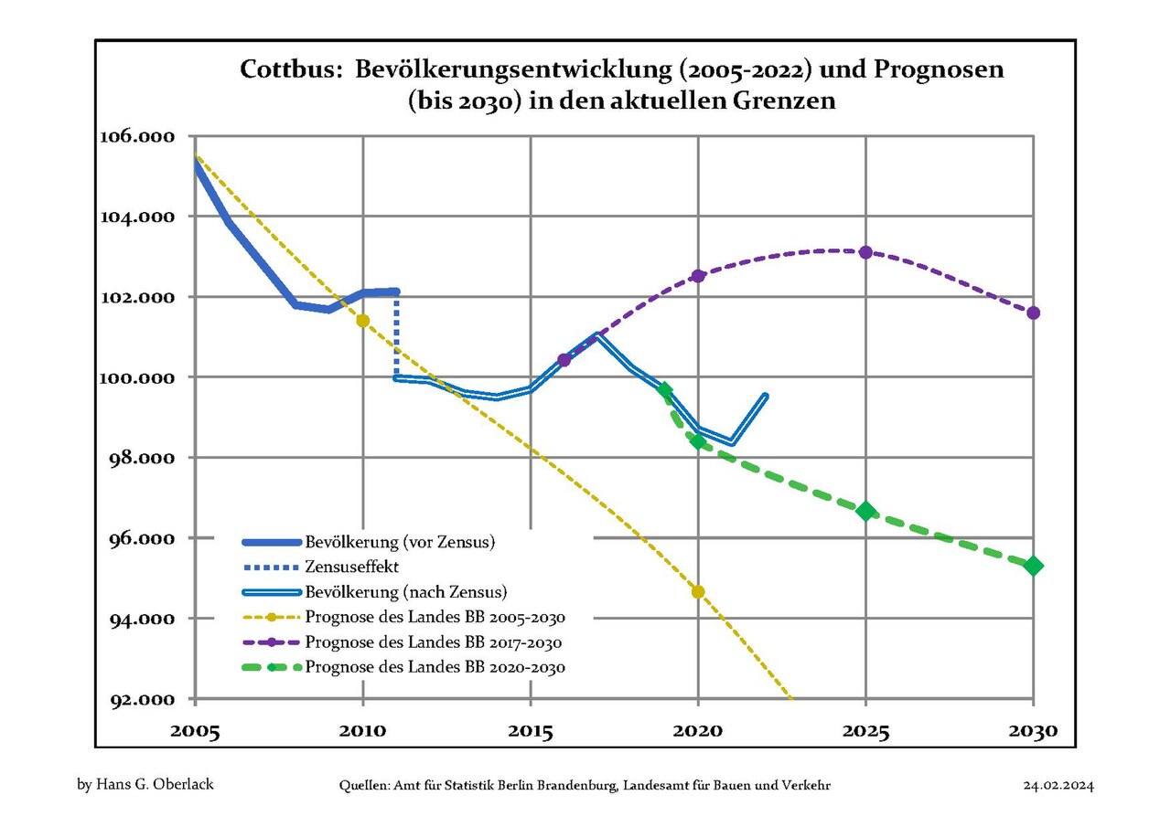
Deutsch: Aktuelle Bevölkerungsentwicklung (blaue Linien) und Prognosen (punktierte Linien) für Cottbus , Landkreis Cottbus, Land Brandenburg, Deutschland
English: Recent population development (blue lines) and projections (dotted lines) of Cottbus, Cottbus district, Brandenburg state, Germany
Español: Tendencias actuales (lineas azules) y previsiones (lineas de puntos) de la poblacion de Cottbus, distrito de Cottbus, estado de Brandenburg, Alemania
Français : Évolution actuelle de la population (lignes bleues) et projections démographiques (lignes pointillées) de Cottbus, arrondissement de Cottbus, Land de Brandebourg, Allemagne
Italiano: Sviluppo recente della popolazione (linea blu) e previsioni demografiche (linea puntata) de Cottbus, circondario de Cottbus, stato federato de Brandeburgo, Germania
Nederlands: Recente ontwikkeling van de bevolking (blauwe lijn) en prognoses (stippelijn) van Cottbus, landkreis Cottbus, deelstaat Brandenburg, Duitsland
Polski: Obecne tendencje (niebieska linia) i prognozy demograficzne (linia przerywana) dla Cottbus, powiat Cottbus, kraj Brandenburgia, Niemcy
Svenska: Aktuella befolkningsutveckling (blå linjen) och prognoser (prickade linjen) av Cottbus, landkreis Cottbus, delstaten Brandenburg, Tyskland |
| Date | 18 Mairch 2012 - 24 Febuair 2024 |
| Soorce | Own work based on: Data sources displayed at Population Projection Brandenburg at Wikimedia Commons |
| Author | Hans G. Oberlack |
| Latest population data | 2022 |
| Latest population forecast | LBV 2020-2030 |
| Type of municipality | kreisfrei |
| Object location | | View this and other nearby images on: OpenStreetMap |
|---|
Licensin
I, the copyright holder of this work, hereby publish it under the following license:
This file is licensed unner the Creative Commons Attribution-Share Alike 3.0 Unported license.
- Ye are free:
- tae share – tae copy, distribute an transmit the wirk
- tae remix – tae adapt the wirk
- Unner the follaein condeetions:
- attribution – Ye must attribute the wirk in the manner specified bi the author or licensor (but nae in ony way that suggests that thay endorse ye or yer uise o the wirk).
- share alik – If ye alter, transform, or big upon this wirk, ye mey distribute the resultin wirk anly unner the same or seemilar license tae this ane.
File history
Clap oan ae date/time fer tae see the file aes it kithed at that time.
| Date/Time | Thummnail | Dimensions | Uiser | Comment | |
|---|---|---|---|---|---|
| current | 13:06, 24 Februar 2024 |  | 1,752 × 1,239 (68 KB) | Hans G. Oberlack | 2020, 2021 and 2022 data added |
| 22:16, 23 September 2022 |  | 1,752 × 1,239 (125 KB) | Hans G. Oberlack | 2021 data added | |
| 19:26, 31 Julie 2021 |  | 1,752 × 1,239 (124 KB) | Hans G. Oberlack | New official forecast and 2020 data added | |
| 16:06, 23 August 2020 | 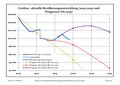 | 1,752 × 1,239 (124 KB) | Hans G. Oberlack | 2019 data added | |
| 21:58, 28 Julie 2019 | 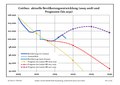 | 1,752 × 1,239 (137 KB) | Hans G. Oberlack | 2018 data added | |
| 20:00, 8 Januar 2019 | 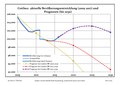 | 1,752 × 1,239 (125 KB) | Hans G. Oberlack | Latest official forecast added | |
| 22:28, 2 October 2018 | 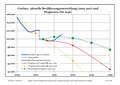 | 1,752 × 1,239 (120 KB) | Hans G. Oberlack | 2017 data added | |
| 12:54, 14 Januar 2018 | 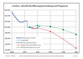 | 1,752 × 1,239 (118 KB) | Hans G. Oberlack | 2016 data added | |
| 23:29, 12 Januar 2017 |  | 1,752 × 1,239 (116 KB) | Hans G. Oberlack | New official forecast and 2015 figures added | |
| 09:24, 19 October 2014 |  | 1,752 × 1,239 (96 KB) | Hans G. Oberlack | 2013 data added |
Eimage airtins
The follaein pages airts tae this image:
Global file uisage
The follaein ither wikis uise this file:
- Uisage on de.wikipedia.org
- Uisage on en.wikipedia.org
- Uisage on th.wikipedia.org