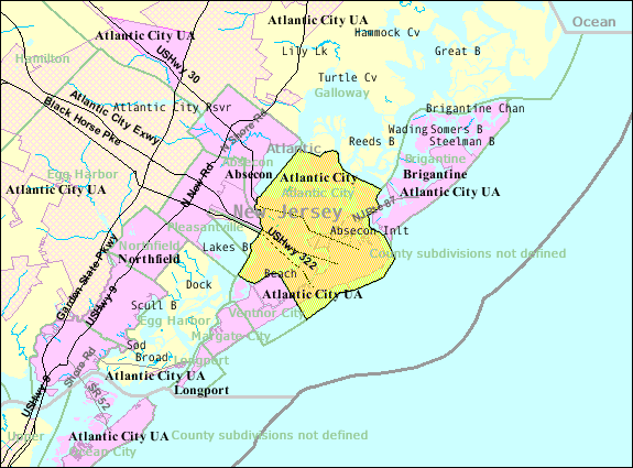
File:Atlantic-city-nj-map.png

Atlantic-city-nj-map.png(575 × 425 pixels, file size: 47 KB, MIME type: image/png)

This file is fae Wikimedia Commons n micht be uised bi ither waurks. The descreeption oan its file descreeption page thaur is shawn ablo.

Ootline

Descreeption U.S. Census 2000 reference map for Atlantic City, New Jersey
Date
Soorce http://factfinder.census.gov
Author United States Census Bureau
Permission
(Reuisin this file)
Public domain

Licensin

Public domain
This image or file is a work of a United States Census Bureau employee, taken or made as part of that person's official duties. As a work of the U.S. federal government, the image is in the public domain.

English  español  日本語  македонски  മലയാളം  português do Brasil  русский  українська  +/−


Original upload log

Transferred from en.wikipedia to Commons using FtCG.

The original description page was here. All following user names refer to en.wikipedia.
Date/Time Dimensions User Comment
15:17, 30 October 2007 575 × 425 (50,641 bytes) w:en:Americasroof (tauk | contreebs) ([[Atlantic City, New Jersey]] map from U.S. Census)

Original upload log

Date/Time Dimensions Uiser Comment
5 Januar 2012, 15:05:36 575 × 425 (50641 bytes) This is also Sven Manguard (tauk · contreebs) Transferred from en.wikipedia: see original upload log above

Captions

Add a one-line explanation of what this file represents

Items portrayed in this file

depicts

checksum Inglis

57db5dbeffd883f96d24942f5977695394a8fc92

data size Inglis

48,177 byte

425 pixel

width Inglis

575 pixel

File history

Clap oan ae date/time fer tae see the file aes it kithed at that time.

Date/TimeThummnailDimensionsUiserComment
current15:22, 18 August 2014Thumbnail fer version aes o 15:22, 18 August 2014575 × 425 (47 KB)GifTaggerBot: Converting file to superior PNG file. (Source: Atlantic-city-nj-map.gif). This GIF was problematic due to non-greyscale color table.

The follaein pages airts tae this image:

Global file uisage

The follaein ither wikis uise this file: