File:Administrative Districts of Germany 1981-2008.svg

Size of this PNG preview of this SVG file: 439 × 599 pixels. Ither resolutions: 176 × 240 pixels | 352 × 480 pixels | 563 × 768 pixels | 750 × 1,024 pixels | 1,500 × 2,048 pixels | 1,351 × 1,844 pixels.
Oreeginal file (SVG file, nominallie 1,351 × 1,844 pixels, file size: 1.39 MB)
Ootline
| Descreeption |
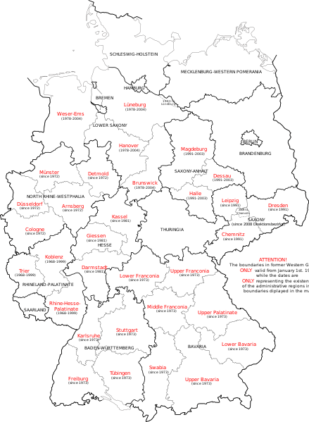
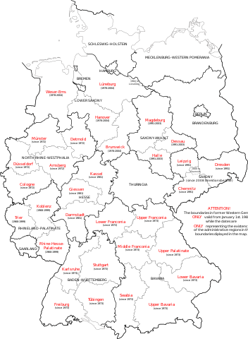
English: Map of Germany showing the boundaries of the Regierungsbezirke for FRG from January 1st 1981 and for Germany till 2008. Also displayed are the former RB of Lower Saxony, Rhineland-Palatinate and Saxony-Anhalt. |
| Date | |
| Soorce | Own work, map translated from Image:Regierungsbezirke_Deutschlands_1981-2008.svg |
| Author | Bennet Schulte |
Licensin
I, the copyright holder of this work, hereby publish it under the following licenses:
This file is licensed unner the Creative Commons Attribution-Share Alike 3.0 Unported license.
- Ye are free:
- tae share – tae copy, distribute an transmit the wirk
- tae remix – tae adapt the wirk
- Unner the follaein condeetions:
- attribution – Ye must attribute the wirk in the manner specified bi the author or licensor (but nae in ony way that suggests that thay endorse ye or yer uise o the wirk).
- share alik – If ye alter, transform, or big upon this wirk, ye mey distribute the resultin wirk anly unner the same or seemilar license tae this ane.

|
Permission is grantit tae copy, distribute an/or modify this document unner the terms o the GNU Free Documentation License, Version 1.2 or ony later version published bi the Free Software Foundation; wi no Invariant Sections, no Front-Cover Texts, an no Back-Cover Texts. A copy o the license is includit in the section enteetled GNU Free Documentation License. |
Ye mey select the license o yer choice.
File history
Clap oan ae date/time fer tae see the file aes it kithed at that time.
| Date/Time | Thummnail | Dimensions | Uiser | Comment | |
|---|---|---|---|---|---|
| current | 14:33, 1 October 2009 | | 1,351 × 1,844 (1.39 MB) | Exec | Neuhaus again |
| 14:29, 1 October 2009 |  | 1,351 × 1,844 (1.39 MB) | Exec | adding fact of Neuhaus | |
| 13:59, 30 September 2009 |  | 1,351 × 1,844 (1.39 MB) | Exec | another translation error solved | |
| 13:56, 30 September 2009 |  | 1,351 × 1,844 (1.39 MB) | Exec | translation error solved | |
| 13:50, 30 September 2009 |  | 1,351 × 1,844 (1.39 MB) | Exec | {{Information |Description={{en|1=Map of Germany showing the boundaries of the Regierungsbezirke for FRG from January 1st 1981 and for Germany till 2008. Also displayed are the former RB of Lower Saxony, Rhineland-Palatinate and Saxony-Anhalt.}} |Source={ |
Eimage airtins
The'r nae pages airts tae this eimage.
Global file uisage
The follaein ither wikis uise this file:
- Uisage on ca.wikipedia.org
- Uisage on en.wikipedia.org
- Uisage on et.wikipedia.org
- Uisage on fr.wikipedia.org
- Uisage on fy.wikipedia.org
- Uisage on gv.wikipedia.org
- Uisage on ia.wikipedia.org
- Uisage on ku.wikipedia.org
- Uisage on ms.wikipedia.org
- Uisage on th.wikipedia.org
- Uisage on uk.wikipedia.org
- Uisage on www.wikidata.org
- Uisage on zh.wikipedia.org