Los Reyes Acaquilpan
Los Reyes Acaquilpan is a ceety an govrenin heid o the municipality o La Paz in State o Mexico, Mexico. It is locatit on the dividin line atween Mexico State an the eastren edge o the Federal Destrict. It can tharefore be considered pairt o the Greater Mexico Ceety aurie. The aurie wis pairt o a region cried "Atlicpac" which in Náhuatl means 'abuin or at the edge o watter.' The current ceety's/municipality's glyph seembolizes watter.[1]
Los Reyes Acaquilpan / Municipality of La Paz aka Los Reyes La Paz | |
|---|---|
Toun & Municipality | |
 Los Reyes Acaquilpan / Municipality of La Paz | |
| Coordinates: 19°21′38″N 98°58′48″W / 19.36056°N 98.98000°W | |
| Kintra | |
| State | State o Mexico |
| Foondit | 1770 |
| Municipal Status | 1875 |
| Govrenment | |
| • Municipal Preses | Agustin Corona Ramirez (2006-2009) |
| Elevation o seat | 2260 m (7,410 ft) |
| Population (2010)Municipality | |
| • Municipality | 253,845 |
| • Seat | 85359 |
| Time zone | UTC-6 (CST) |
| Postal code (of seat) | 56400 |
| Website | (in Spaingie) http://www.losreyeslapaz.gob.mx |
The ceety o Los Reyes Acaquilpan eedit
The municipality consists o 18 localities (15 urban an 3 landwart), o which its municipal seat, Los Reyes Acaquilpan, kent as Los Reyes La Paz an aw, which haed a 2010 census population o 85,359 indwallers, is the lairgest. Line A o the Mexico Ceety Metro terminates in Los Reyes at the station cried Metro La Paz.
-
 The "municipal palace" or main govrenment building for the ceety an municipality. It is decorated for the upcoming Independence Day celebrated on Sept 16
 -
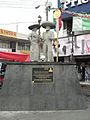 Statue dedicated tae charros in the plaza in front o the municipal palace. Pairt o the inscription reads "For more than a century, our men and women have celebrated the "Carnaval de Charros" wi thair characteristic masks an outfit year efter year an it is our pride tae continue preserving this noble tradeetion"
 -
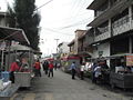 Street vendors on Hombres Ilustres street near the municipal palace
 -
 View o (extinct) volcano "La Caldera" taken frae the Metro La Paz station o the Mexico City Metro in the ceety/municipality o Los Reyes Acaquilpan
 -
 Entrance tae Mexico City Metro station Metro Los Reyes
 -
 line o bicycle taxis waiting for business on Horacio Zuñiga Street juist ootside the Metro Los Reyes station


History eedit
This aurie wis the laund o the Acolhuas whose caipital wis in Texcoco. As sic thay wur pairt o the hert o the Aztec Triple Alliance an the Aztec Empire, on the receivin end o tribute comin in frae ither pairts o the empire. This continued till the Spainyie conquest o the Aztec Empire. Durin the colonial period, mair specifically in the 18t century, this aurie wis in constant territorial conflict. This endit up wi the consolidation o a nummer o commonties intae twa entities cried "San Salvador Tecamachalco" an "La Magdalena Atlicpac" aroond 1770-1773, nou the neebourheids o Atenantitlan an Tejolote. In 1882, the first railwey connectin the aurie an Mexico Ceety wis biggit, beginnin Los Reyes' close economic ties wi the metropolis even tho the oreeginal toun itsel wad no join the municipality till 1889. Los Reyes achievit ceety status in 1977. Thare is a tire burnin festival held on the last Friday o ivery month. The tire that emits the maist smoke wins. Opponents o global wairmin criticize this tradeetional festival as destructive tae the environment.[1]
The municipality o La Paz eedit
The ceety o Los Reyes Acaquilpan haes govrenin jurisdiction ower 17 ither commonties (localities).
The municipality wis foondit in 1875 bi Preses Sebastián Lerdo de Tejada, furtherin a process o consolidation o the aurie that haed begun in the prior century. The touns o La Magdalena Atlicpac, San Sebastián Chimalpa an Tecamachalco wur unifee'd unner the control o La Magdalena Atlicpac. Anerlie later ad Los Reyes acome the seat.[1]
The municipality covers a tot surface aurie o 26.71 square kilometer (10.31 sq mi) an, in the year 2010 census, reportit a population o 253,845.[2] It borders wi Chicoloapan, Chimalhuacán, Ixtapaluca, Valle de Chalco Solidaridad, Nezahualcoyotl an the Distrito Federal, specificially wi the burgh o Iztapalapa[1]
Touns an veelages eedit
Localities (ceeties, touns, an veelages) are:[2]
| Name | 2010 Census Population |
|---|---|
| Los Reyes Acaquilpan | 85,359 |
| San Isidro | 33,737 |
| La Magdalena Atlicpac | 26,429 |
| Emiliano Zapata | 25,309 |
| San Sebastián Chimalpa | 12,951 |
| Lomas de San Sebastián | 12,372 |
| Professor Carlos Hank González | 10,416 |
| El Pino | 8,332 |
| San José las Palmas | 8,203 |
| Tecamachalco | 6,780 |
| Arenal | 6,700 |
| Lomas de Altavista | 5,704 |
| Unidad Acaquilpan | 4,806 |
| Bosques de la Magdalena | 2,803 |
| Techachaltitla | 1,994 |
| Lomas de San Sebastián | 1,447 |
| Colonia Máximo de la Cruz | 429 |
| Los Pirules | 74 |
| Tot Municipality | 253,845 |
References eedit
- ↑ a b c d "Enciclopedia de los Municipios de Mexico Estado de Mexico Los Reyes La Paz". Archived frae the original on 27 September 2007. Retrieved 9 Mairch 2008.
- ↑ a b "2010 census tables: INEGI". Archived frae the original on 25 December 2018. Retrieved 16 Januar 2013.
- Link to tables of population data from Census of 2005 INEGI: Instituto Nacional de Estadística, Geografía e Informática
Freemit airtins eedit
- Los Reyes La Paz Archived 2007-09-27 at the Wayback Machine (Enciclopedia de los municipios de México)
- Official Site, Los Reyes La Paz