Kafr el-Sheikh Govrenorate
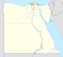
Kafr el-Sheikh Govrenorate (Arabic: محافظة كفر الشيخ Muḥāfaẓat Kafr aš Šayḫ) is ane o the govrenorates o Egyp. It lies in the north o the kintra alang the wastren branch o the Nile in the Nile Delta. Its caipital is the ceety o Kafr el-Sheikh.

History eedit
Kafr el-Sheikh Govrenorate, which wis ance pairt o the Gharbia Govrenorate, wis creatit in 1949. It wis oreeginally named Fuadiyah in honour o Keeng Fuad I o Egyp. Efter the 1952 Revolution an the subsequent abolition o the monarchy, the govrenorate teuk the name o its caipital ceety Kafr el-Sheikh. This name, adoptit in 1955, means "the veelage o the chief".[1]
The region occupied the day bi the Kafr el-Sheikh govrenorate haes been weel kent syne the era o the Auncient Egyptian. The caipital o Lawer Egyp, cried "Puto", is locatit the day at Tel el-Faraain (the hill o the Pharaohs), near Desouk.
Geography eedit
Lake Burullus is locatit in the north o the Kafr el-Sheikh govrenorate.
The govrenorate comprises 11 ceeties:
Economy eedit
Industries include cotton-processin factories, rice an fishin.
Education eedit
Kafr el-Sheikh Varsity comprises faculties for Commerce, Ingineerin, Agricultur, Veterinary Medicine, Airts, Pheesical Eddication, Science, Eddication, an Special Eddication.
Notable fowk frae Kafr el-Sheikh govrenorate eedit
- Ibrahim El-Desouki, Muslim saunt.
- Ahmed Zewail, Egyptian American scientist
- Hossam Ghaly, Egyptian fitbawer
- Osama Anwar Okasha, Egyptian screenwriter an jurnalist
- Saad Zaghloul, Egyptian politeecian
References eedit
- ↑ Room, Adrian (2006). Placenames of the World: Origins and Meanings of the Names for 6,600 Countries, Cities, Territories, Natural Features, and Historic Sites (2nd ed.). Jefferson, NC: McFarland. p. 185. ISBN 9780786422487. Retrieved 7 August 2010.
Freemit airtins eedit
| Wikimedia Commons haes media relatit tae Kafr el-Sheikh Governorate. |
Govrenment eedit
- Offeecial Kafr el-Sheikh Govrenorate wabsteid Archived 2006-02-07 at the Wayback Machine
- Offeecial Kafr el-Sheikh Govrenorate trade point websteid Archived 2006-01-16 at the Wayback Machine
- UNDP Kafr ash Shaykh Human Development Index Indicator's page Archived 2005-12-28 at Archive.today
Local Portals an Guides eedit
- Kfrawy.com: Kafr el-Sheikh Govrenorate guide Archived 2006-02-05 at the Wayback Machine