File:India Kerala Thiruvananthapuram district.svg

Size of this PNG preview of this SVG file: 411 × 599 pixels. Ither resolutions: 164 × 240 pixels | 329 × 480 pixels | 527 × 768 pixels | 702 × 1,024 pixels | 1,405 × 2,048 pixels | 874 × 1,274 pixels.
Oreeginal file (SVG file, nominallie 874 × 1,274 pixels, file size: 539 KB)
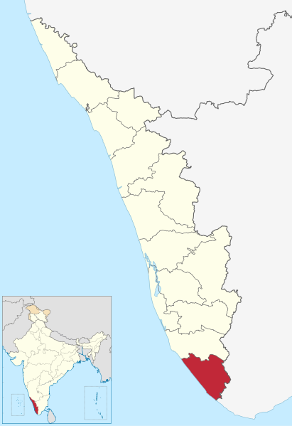
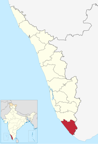
| Descreeption | Location of Thiruvananthapuram district in Kerala |
| Date | (UTC) |
| Soorce | |
| Author |
|
I, the copyright holder of this work, hereby publish it under the following license:
This file is licensed unner the Creative Commons Attribution-Share Alike 3.0 Unported license.
- Ye are free:
- tae share – tae copy, distribute an transmit the wirk
- tae remix – tae adapt the wirk
- Unner the follaein condeetions:
- attribution – Ye must attribute the wirk in the manner specified bi the author or licensor (but nae in ony way that suggests that thay endorse ye or yer uise o the wirk).
- share alik – If ye alter, transform, or big upon this wirk, ye mey distribute the resultin wirk anly unner the same or seemilar license tae this ane.
Original upload log
This image is a derivative work of the following images:
- File:India_Kerala_location_map.svg licensed with Cc-by-sa-3.0
- 2011-03-11T09:30:07Z NordNordWest 827x1205 (135528 Bytes) =={{int:filedesc}}== {{Information |Description= {{de|Positionskarte von [[:de:Kerala|Kerala]], [[:de:Indien|Indien]]}} Quadratische Plattkarte, N-S-Streckung 102 %. Geographische Begrenzung der Karte: * N: 13.0° N * S: 8.0�
Uploaded with derivativeFX
File history
Clap oan ae date/time fer tae see the file aes it kithed at that time.
| Date/Time | Thummnail | Dimensions | Uiser | Comment | |
|---|---|---|---|---|---|
| current | 16:54, 10 Juin 2023 | | 874 × 1,274 (539 KB) | C1MM | updated bounds |
| 06:37, 4 September 2021 |  | 775 × 1,129 (507 KB) | C1MM | c bounds | |
| 11:21, 3 Apryle 2011 |  | 827 × 1,205 (72 KB) | BishkekRocks | fix | |
| 14:13, 11 Mairch 2011 |  | 827 × 1,205 (76 KB) | BishkekRocks | {{Information |Description=Location of Thiruvananthapuram district in Kerala |Source=*File:India_Kerala_location_map.svg |Date=2011-03-11 14:09 (UTC) |Author=*File:India_Kerala_location_map.svg: {{U|NordNordWest}} *derivative work: ~~~ |Permis |
Eimage airtins
The follaein pages airts tae this image:
Global file uisage
The follaein ither wikis uise this file:
- Uisage on ar.wikipedia.org
- Uisage on arz.wikipedia.org
- Uisage on bn.wikipedia.org
- Uisage on ceb.wikipedia.org
- Uisage on de.wikipedia.org
- Uisage on en.wikipedia.org
- Thiruvananthapuram
- Kovalam
- Attingal
- Neyyattinkara
- Varkala
- Nedumangad
- Kazhakoottam
- Amboori
- Thiruvananthapuram district
- Peroorkada
- Aakkulam
- Singarathoppe
- Vithura
- Sreekaryam
- Nemom
- Vizhinjam
- Thennoor
- Balaramapuram
- Nalanchira
- Karamana
- Poovar
- Aruvippuram
- Puthenthope
- East Fort
- Aryanadu
- Cherunniyoor
- Kaniyapuram
- Pallithura
- Navaikulam
- Pothencode
- Pakalkuri
- Kadinamkulam
- Kesavadasapuram
- Valiyavila
- Venganoor
- Chempazhanthy
- Bonacaud
- Tourism in Thiruvananthapuram
- Kunnathukal
- Moothala
- Karicharakadavu
- Thonnakkal
- Mandapathinkadavu
- Poojappura
View mair global usage o this file.