File:Flusssystemkarte Rhein 04.jpg

Size o this luikower: 441 × 599 pixels. Ither resolutions: 177 × 240 pixels | 353 × 480 pixels | 565 × 768 pixels | 754 × 1,024 pixels | 1,508 × 2,048 pixels | 3,198 × 4,344 pixels.
Oreeginal file (3,198 × 4,344 pixels, file size: 11.72 MB, MIME type: image/jpeg)
Ootline
| Descreeption |
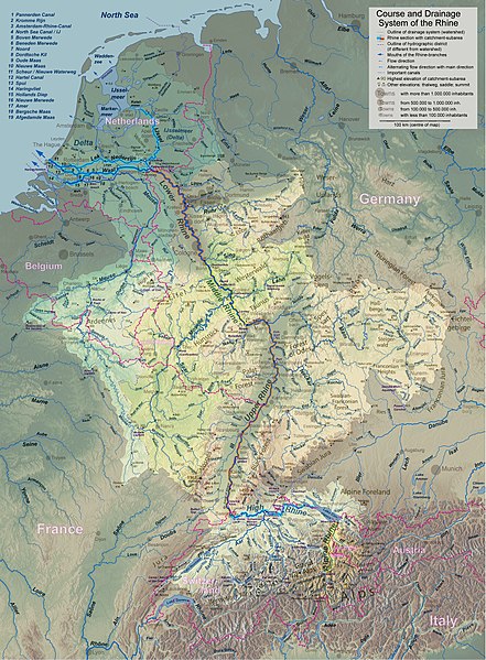
English: Rhine course and river system, place names in English Deutsch: Rheinlauf und Flusssystem, englisch beschriftet Français : Cours du Rhin et son bassin versant, noms de lieux en anglais Nederlands: Verloop en rivierensysteem van de Rijn, plaatsnamen in Engels |
| Date | |
| Soorce | Ain wirk |
| Author | WWasser |
| Other versions | Versions in german, french, dutch, or with local names. For other languages the unlabelled version may be used. There are also less detailed maps of the river system with either german, english, french, dutch, or local names. A small version without names is available, too. |
| Camera location | | View this and other nearby images on: OpenStreetMap |
|---|
- Background relief created with Google Maps-For-Free SRTM3 Webserver
- Topography derived from Open Street Map
- Outlines of catchment areas derived from relief data (in the Netherlands also taken from several ICPR (International Commission for the Protection of the Rhine)- and Rijkswaterstaat-publications)
Licensin
I, the copyright holder of this work, hereby publish it under the following license:
This file is licensed unner the Creative Commons Attribution-Share Alike 3.0 Unported license.
- Ye are free:
- tae share – tae copy, distribute an transmit the wirk
- tae remix – tae adapt the wirk
- Unner the follaein condeetions:
- attribution – Ye must attribute the wirk in the manner specified bi the author or licensor (but nae in ony way that suggests that thay endorse ye or yer uise o the wirk).
- share alik – If ye alter, transform, or big upon this wirk, ye mey distribute the resultin wirk anly unner the same or seemilar license tae this ane.
File history
Clap oan ae date/time fer tae see the file aes it kithed at that time.
| Date/Time | Thummnail | Dimensions | Uiser | Comment | |
|---|---|---|---|---|---|
| current | 18:26, 17 September 2017 | | 3,198 × 4,344 (11.72 MB) | WWasser | Albertkanaal, Aa (Dommel), frontier lines in Lake of Constance |
| 12:23, 18 Apryle 2013 |  | 2,399 × 3,255 (4.7 MB) | WWasser | more details | |
| 16:34, 4 Apryle 2013 |  | 2,131 × 2,892 (4.22 MB) | WWasser | {{Information |Description ={{en|1=legend and colours, more toponyms translated}} |Source =own work |Author =own work |Date = |Permission = |other_versions = }} | |
| 13:49, 5 Mairch 2013 |  | 2,131 × 2,894 (3.32 MB) | WWasser | some smaller rivers, elevations | |
| 12:56, 8 Februar 2013 |  | 2,131 × 2,896 (3.07 MB) | WWasser | {{Information |Description ={{en|1=colours improved}} |Source =own |Author =WWasser |Date = |Permission = |other_versions = }} | |
| 09:03, 8 Februar 2013 |  | 2,131 × 2,896 (3.11 MB) | WWasser | {{Information |Description ={{en|1=lower, more appropriate resolution}} |Source =own |Author =User:WWasser|WWasser |Date =2013-02-05 |Permission = |other_versions = }} | |
| 16:04, 5 Februar 2013 |  | 4,262 × 5,791 (4.22 MB) | WWasser | User created page with UploadWizard |
Eimage airtins
The follaein pages airts tae this image:
Global file uisage
The follaein ither wikis uise this file:
- Uisage on ang.wikipedia.org
- Uisage on ast.wikipedia.org
- Uisage on as.wikipedia.org
- Uisage on av.wikipedia.org
- Uisage on azb.wikipedia.org
- Uisage on ban.wikipedia.org
- Uisage on ba.wikipedia.org
- Uisage on be-tarask.wikipedia.org
- Uisage on be.wikipedia.org
- Uisage on bh.wikipedia.org
- Uisage on da.wikipedia.org
- Uisage on en.wikipedia.org
- Uisage on fa.wikipedia.org
- Uisage on gv.wikipedia.org
- Uisage on he.wikipedia.org
- Uisage on hi.wikipedia.org
- Uisage on id.wikipedia.org
- Uisage on ilo.wikipedia.org
- Uisage on kk.wikipedia.org
- Uisage on kw.wikipedia.org
- Uisage on lfn.wikipedia.org
- Uisage on lij.wikipedia.org
- Uisage on ml.wikipedia.org
- Uisage on nl.wikipedia.org
- Uisage on ru.wikipedia.org
- Uisage on sd.wikipedia.org
- Uisage on simple.wikipedia.org
- Uisage on th.wikipedia.org
- Uisage on tr.wikipedia.org