File:Flag of Cambodia under Japanese occupation.svg

Size of this PNG preview of this SVG file: 750 × 500 pixels. Ither resolutions: 320 × 213 pixels | 640 × 427 pixels | 1,024 × 683 pixels | 1,280 × 853 pixels | 2,560 × 1,707 pixels.
Oreeginal file (SVG file, nominallie 750 × 500 pixels, file size: 529 bytes)
Ootline
| Descreeption |
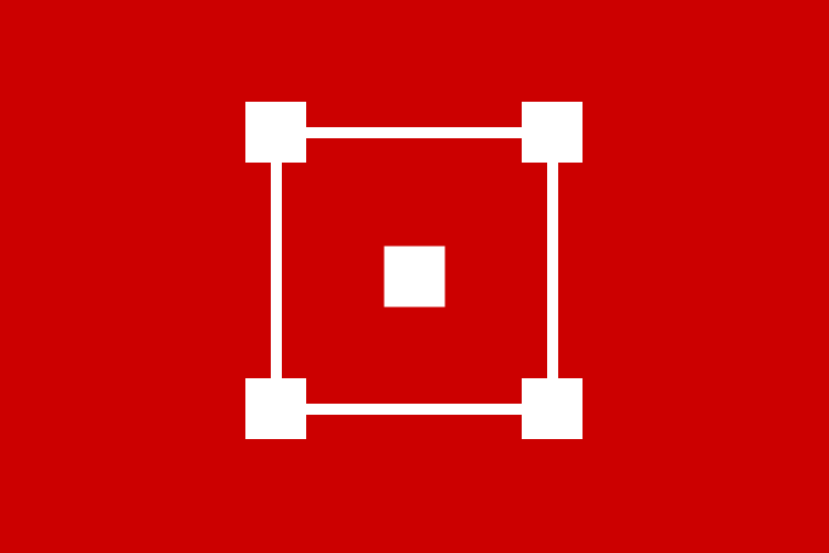
Dubious claimed Flag of Cambodia under Japanese occupation.[1]
|
| Date | 23 November 2006 (original upload date) |
| Soorce | Ain wirk based on publicly-available information |
| Author | Lexicon (SVG file) |
Licensin
I, the copyright holder of this work, hereby publish it under the following licenses:

|
Permission is grantit tae copy, distribute an/or modify this document unner the terms o the GNU Free Documentation License, Version 1.2 or ony later version published bi the Free Software Foundation; wi no Invariant Sections, no Front-Cover Texts, an no Back-Cover Texts. A copy o the license is includit in the section enteetled GNU Free Documentation License. |
| This file is licensed unner the Creative Commons Attribution-Share Alike 3.0 Unported license. | ||
| ||
| This licensing tag was added to this file as part of the GFDL licensing update. |
This file is licensed under the Creative Commons Attribution-Share Alike 2.5 Generic, 2.0 Generic and 1.0 Generic license.
- Ye are free:
- tae share – tae copy, distribute an transmit the wirk
- tae remix – tae adapt the wirk
- Unner the follaein condeetions:
- attribution – Ye must attribute the wirk in the manner specified bi the author or licensor (but nae in ony way that suggests that thay endorse ye or yer uise o the wirk).
- share alik – If ye alter, transform, or big upon this wirk, ye mey distribute the resultin wirk anly unner the same or seemilar license tae this ane.
Ye mey select the license o yer choice.

|
This image shows a flag, a coat of arms, a seal or some other official insignia. The use of such symbols is restricted in many countries. These restrictions are independent of the copyright status. |
File history
Clap oan ae date/time fer tae see the file aes it kithed at that time.
| Date/Time | Thummnail | Dimensions | Uiser | Comment | |
|---|---|---|---|---|---|
| current | 02:53, 19 Februar 2012 | | 750 × 500 (529 bytes) | AnonMoos | simplify |
| 15:36, 23 November 2006 |  | 750 × 500 (3 KB) | Lexicon |
Eimage airtins
The follaein pages airts tae this image:
Global file uisage
The follaein ither wikis uise this file:
- Uisage on ab.wikipedia.org
- Uisage on ace.wikipedia.org
- Uisage on af.wikipedia.org
- Uisage on ar.wikipedia.org
- Uisage on ary.wikipedia.org
- Uisage on arz.wikipedia.org
- Uisage on ast.wikipedia.org
- Uisage on as.wikipedia.org
- Uisage on azb.wikipedia.org
- Uisage on ban.wikipedia.org
- Uisage on ba.wikipedia.org
- Uisage on bcl.wikipedia.org
- Uisage on be-tarask.wikipedia.org
- Uisage on be.wikipedia.org
- Другая сусветная вайна
- Другая япона-кітайская вайна (1937—1945)
- Краіны Восі
- Сцяг Камбоджы
- Шаблон:Сцягафікацыя/Камбоджа
- Маньчжоу-го
- Шаблон:Вялікая ўсходнеазіяцкая сфера ўзаемнага росквіту
- Паўднёвы Ціхаакіянскі мандат
- Ціхаакіянскі тэатр ваенных дзеянняў Другой сусветнай вайны
- Дзяржава Бірма
- В’етнамская імперыя
- Урад Вялікага шляху
- Тыморская аперацыя
- Мэнцзян
- Японская акупацыя Камбоджы
- Квантунская вобласць
- Карафута
- Тайвань пад кіраваннем Японіі
- Uisage on bg.wikipedia.org
- Uisage on bh.wikipedia.org
- Uisage on bjn.wikipedia.org
- Uisage on blk.wikipedia.org
- Uisage on bn.wikipedia.org
View mair global usage o this file.