File:Djerba topographic map-fr.svg

Size of this PNG preview of this SVG file: 666 × 599 pixels. Ither resolutions: 267 × 240 pixels | 533 × 480 pixels | 853 × 768 pixels | 1,138 × 1,024 pixels | 2,276 × 2,048 pixels | 1,100 × 990 pixels.
Oreeginal file (SVG file, nominallie 1,100 × 990 pixels, file size: 564 KB)
Ootline
| Camera location | | View this and other nearby images on: OpenStreetMap |
|---|
| Descreeption |
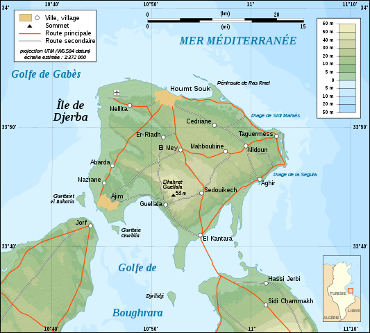
English: Topographic map in French of Djerba Island, Tunisia.
Note: The shaded relief is a raster image embedded in the SVG file. Français : Carte topographique en français de l'île de Djerba, Tunisie.
Note : Les ombres du relief sont une image bitmap embarquée dans le fichier SVG. Norsk bokmål: Topografisk kart over Djerba i Tunisia, på fransk.
UTM projection ; WGS84 datum ; shaded relief (composite image of N-W and N lightning positions) ; |
||
| Date | |||
| Soorce |
Own work ;
|
||
| Author | Eric Gaba (Sting - fr:Sting) | ||
| Permission (Reuisin this file) |
|
||
| Other versions |
Derivative works of this file: []
|


|
This SVG file contains embedded text that can be translated into your language, using any capable SVG editor, text editor or the SVG Translate tool. For more information see: About translating SVG files. |
Licensin
I, the copyright holder of this work, hereby publish it under the following licenses:

|
Permission is grantit tae copy, distribute an/or modify this document unner the terms o the GNU Free Documentation License, Version 1.2 or ony later version published bi the Free Software Foundation; wi no Invariant Sections, no Front-Cover Texts, an no Back-Cover Texts. A copy o the license is includit in the section enteetled GNU Free Documentation License. |
This file is licensed under the Creative Commons Attribution-Share Alike 4.0 International, 3.0 Unported, 2.5 Generic, 2.0 Generic and 1.0 Generic license.
- Ye are free:
- tae share – tae copy, distribute an transmit the wirk
- tae remix – tae adapt the wirk
- Unner the follaein condeetions:
- attribution – Ye must attribute the wirk in the manner specified bi the author or licensor (but nae in ony way that suggests that thay endorse ye or yer uise o the wirk).
- share alik – If ye alter, transform, or big upon this wirk, ye mey distribute the resultin wirk anly unner the same or seemilar license tae this ane.
Ye mey select the license o yer choice.
File history
Clap oan ae date/time fer tae see the file aes it kithed at that time.
| Date/Time | Thummnail | Dimensions | Uiser | Comment | |
|---|---|---|---|---|---|
| current | 01:09, 1 September 2008 | | 1,100 × 990 (564 KB) | Sting | New standard colors |
| 20:07, 5 December 2007 |  | 1,100 × 990 (571 KB) | Sting | Forgotten village name | |
| 10:44, 5 December 2007 |  | 1,100 × 990 (571 KB) | Sting | "Ras Rmel" typo correction | |
| 23:11, 4 December 2007 |  | 1,100 × 990 (571 KB) | Sting | {{Location|33|45|00|N|10|55|00|E|scale:500000}} <br/> {{Information |Description=Topographic map in French of Djerba Island, Tunisia |Source=Own work ;<br/>Topographic map : [http://www2.jpl.nasa.gov/srtm NASA Shuttle Radar Topography Missi |
Eimage airtins
The follaein pages airts tae this image:
Global file uisage
The follaein ither wikis uise this file:
- Uisage on da.wikipedia.org
- Uisage on en.wikipedia.org
- Uisage on eo.wikipedia.org
- Uisage on fa.wikipedia.org
- Uisage on fr.wikipedia.org
- Uisage on fr.wiktionary.org
- Uisage on gl.wikipedia.org
- Uisage on he.wikipedia.org
- Uisage on incubator.wikimedia.org
- Uisage on it.wikipedia.org
- Uisage on lad.wikipedia.org
- Uisage on pl.wikipedia.org
- Uisage on pt.wikipedia.org
- Uisage on sc.wikipedia.org