File:Calle de Alcalá 151 (Madrid) 01.jpg

Size o this luikower: 800 × 594 pixels. Ither resolutions: 320 × 237 pixels | 640 × 475 pixels | 1,024 × 760 pixels | 1,280 × 950 pixels | 2,560 × 1,900 pixels | 3,013 × 2,236 pixels.
Oreeginal file (3,013 × 2,236 pixels, file size: 1.63 MB, MIME type: image/jpeg)
| Descreeption |
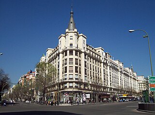
English: Building at 151 Calle de Alcalá (street, right) in Madrid (Spain), in Salamanca district. Built between 1940 and 1950. Left: Calle del Conde de Peñalver (street).
Español: Edificio en el nº 151 de la Calle de Alcalá (derecha) de Madrid (España), en el distrito de Salamanca. Construido entre 1940 y 1950. A la izquierda, Calle del Conde de Peñalver. |
||
| Date | |||
| Soorce | Ain wirk | ||
| Author | Luis García (Zaqarbal) | ||
| Permission (Reuisin this file) |
I, the copyright holder of this work, hereby publish it under the following licenses:
This file is licensed under the Creative Commons Attribution-Share Alike 3.0 Unported, 2.5 Generic, 2.0 Generic and 1.0 Generic license. Attribution: Luis García
Ye mey select the license o yer choice. |

_01.jpg)
| Object location | | View this and other nearby images on: OpenStreetMap |
|---|
_01.jpg¶ms=040.425217_N_-003.675414_E_globe:Earth_class:object_type:landmark_region:ES_&language=sco)
File history
Clap oan ae date/time fer tae see the file aes it kithed at that time.
| Date/Time | Thummnail | Dimensions | Uiser | Comment | |
|---|---|---|---|---|---|
| current | 07:01, 23 Mairch 2009 | | 3,013 × 2,236 (1.63 MB) | Zaqarbal | Taken by Luis García (Zaqarbal) on March 13, 2009. Hereby published under GFDL and Cc-by-sa-3.0,2.5,2.0,1.0 licenses. <!--{{ImageUpload|basic}}--> |
Eimage airtins
The follaein pages airts tae this image:
Global file uisage
The follaein ither wikis uise this file:
- Uisage on ca.wikipedia.org
- Uisage on en.wikipedia.org
- Uisage on eo.wikipedia.org
- Uisage on es.wikipedia.org
- Uisage on he.wikipedia.org
- Uisage on it.wikivoyage.org
- Uisage on ja.wikipedia.org
- Uisage on nl.wikipedia.org
- Uisage on pt.wikipedia.org
- Uisage on qu.wikipedia.org
_01.jpg)