Bani Suheila
Bani Suheila (Arabic: بني سهيلا) is a Palestinian ceety in the soothren Gaza Strip's Khan Yunis Govrenorate. Accordin tae the Palestinian Central Bureau o Statistics the population o Bani Suheila haed grown frae 8,220 in 1945 tae 32,800 fowk in mid-year 2006.[1][2]
Bani Suheila | |
|---|---|
| Ither transcription(s) | |
| • Arabic | بني سهيلا |
Official logo of Bani Suheila Municipal Logo o Bani Suheila | |
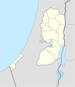
Location o Bani Suheila within the Palestinian territories | |
| Coordinates: 31°20′34″N 34°19′31″E / 31.34278°N 34.32528°ECoordinates: 31°20′34″N 34°19′31″E / 31.34278°N 34.32528°E | |
| Palestine grid | 85/83 |
| Govrenorate | Khan Yunis |
| Govrenment | |
| • Teep | Ceety |
| • Heid o Municipality | 5.1 |
| Area | |
| • Jurisdiction | 5.17 km2 (2.00 sq mi) |
| Population (2007) | |
| • Jurisdiction | 33,767 |
| Website | www.banisuhaila.org |
Durin the nicht o August 31, 1955, Israeli airmit forces attacked Bani Suheila.[3] On 5 Aprile 1956 Israeli airtillery shelled the toun.[4]
References eedit
- ↑ Palestinian Central Bureau of Statistics Archived 2012-02-07 at the Wayback Machine Projected Mid -Year Population for Khan Yunis Governorate by Locality 2004- 2006
- ↑ A Survey of Palestine: Prepared in December 1945 and January 1946 for the Information of the Anglo-American Committee of Inquiry By Anglo-American Committee of Inquiry on Jewish Problems in Palestine and Europe, United Nations General Assembly. Special Committee on Palestine Published by Institute for Palestine Studies, 1991 ISBN 0887282113 p 132
- ↑ al-Sayyid Muḥammad ʻAlī Nawfal (1965) Israel's crime record Information Dept. p 28
- ↑ Morris, Benny (1993) Israel's Border Wars, 1949-1956: Arab Infiltration, Israeli Retaliation, and the Countdown to the Suez War. Oxford University Press, ISBN 0198292627 p 388
